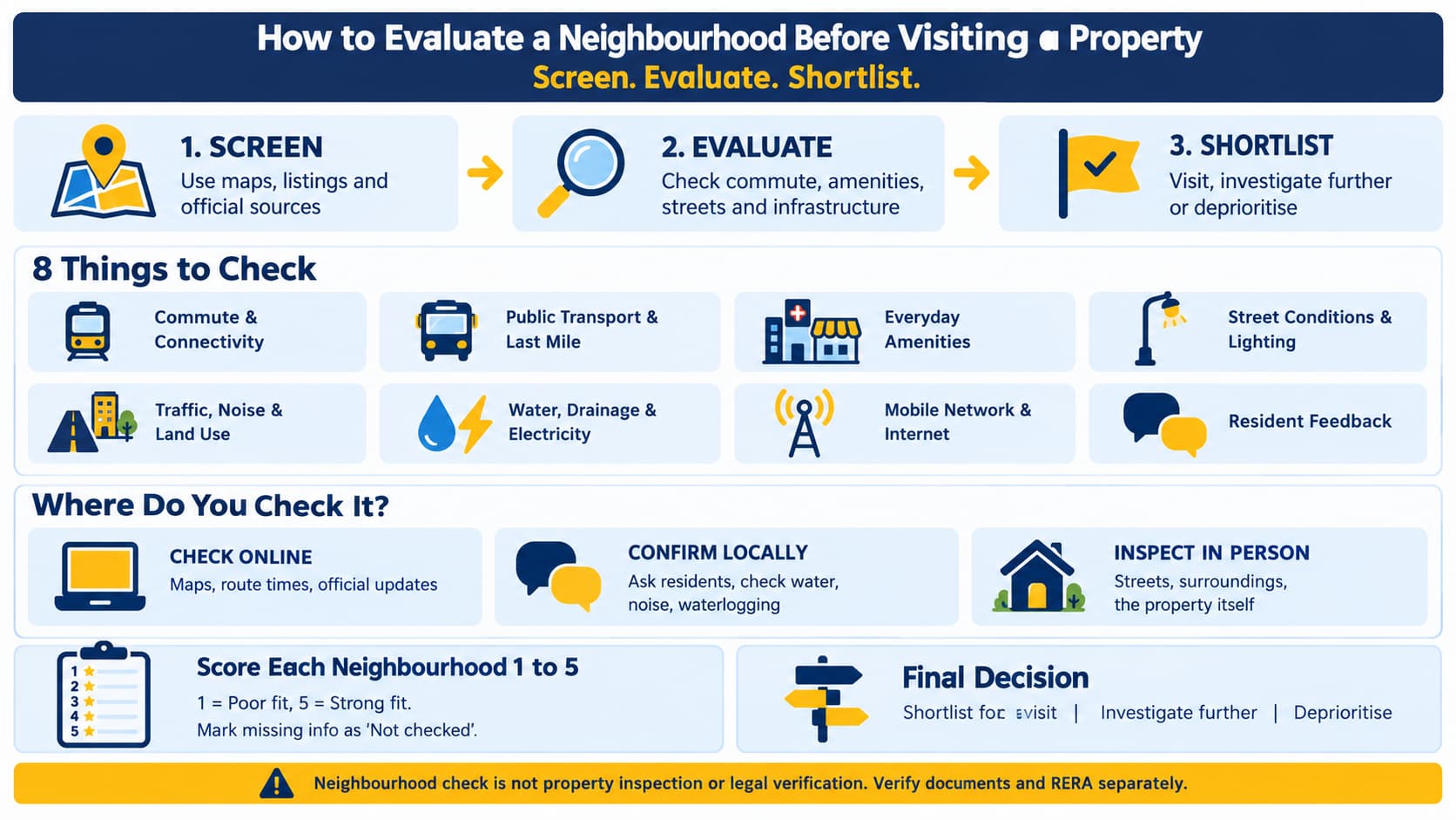
The cost of a site visit includes time, gas, and even one day off. Many people discover, when at last they get into a flat, that their travel would be extremely difficult, that the closest pharmacy would be far from there, and that the road leading to the building gets flooded every monsoon. Learning how to screen a neighborhood before a site visit will help you avoid such problems and spend your weekend in places that are worth your time.
This article will show you how to go about three stages of screening your potential real estate: screening of the locality with the use of maps, advertisements, and official information, evaluation of practical aspects including commute, amenities and infrastructures, and shortlisting of places that need to be physically visited.
Why Evaluate a Neighbourhood Before Visiting a Property?
A community makes much more impact on your everyday life than any room in your home. Renovation can change your kitchen, but it cannot influence a road outside or shorten the distance to your workplace.
A preliminary evaluation will give you an advantage in three aspects. Firstly, it eliminates all locations, which are not suitable for your routine. Secondly, it helps you to compare different options using the same set of criteria. Thirdly, it will provide you with a list of questions to check on the spot.
Let us have two shortlisted flats. Flat A is somewhat cheaper, while its distance to your office on the map is only 6 km. Flat B is 9 km away from your workplace, but it is located next to the metro station, pharmacy and grocery market. When you check the route to Flat A at 9 a.m. and find that it goes through a busy junction, it does not have any transport and you need to walk to the major street, then "shorter" distance may mean more difficult travel everyday. It is worth visiting Flat B first. Of course, those numbers are just illustrative, not actual data of any locality.
A simple way to organise your thinking is to sort every check into three groups:
Verify online: commutation details, maps, facility locations, and project status.
Verify locally: availability of water, electricity, water logging issues, noise, and resident experience.
Examine personally: the street experience, footpaths, surroundings of buildings, and the property itself.
Check Commute Time, Connectivity and Last-Mile Access
Start with the journeys you will make most often: work, your children's school or college, and visits to family or a hospital.
Map the real route. Consider the real routes rather than the distance between two points.
Consider public transport. Observe the metro stations, local train stations, and bus stops nearby and their frequency of operation along the way.
Consider last-mile connectivity. Last mile connectivity is an important factor as it determines convenience. Observe the walkable distance from your location to the stop, number of road crossings, and availability of auto rickshaws, shared auto rickshaws, and feeders.
Try during peak hours. Consider the real time estimates of the route at the time of actual commute, say 8:30 a.m. and 6:30 p.m., and also consider alternative routes during peak traffic hour.
The straight-line distance might sometimes give false impressions. The distance of 4 km from the destination in case of a river, railway, or overpass with restricted access points may take more time to reach than the destination of 8 km away from the present location in an area with a straight line path.
Evaluate Everyday Amenities Before Scheduling a Visit
A pin on the map shows that a facility exists, but not whether it suits you. For each essential service, check how you would actually use it.
Healthcare: Hospitals, clinics, and pharmacies.
Check availability of an emergency center and timing of operations of the pharmacy.
Education and Childcare: Schools, colleges, and creches.
Daily requirements: Groceries, markets, and laundry service.
Open spaces: Parks, playfields, and places for walks.
Frequent services: ATMs, bus stops, auto stands, and fuel pumps.
Consider opening hours, the path to the location and your own needs. The proximity of a school might not be good for you if it works on a board that does not appeal to you. The hospital might not be very useful if it is located 5 km away and is congested during traffic hours.
Assess Street Conditions, Lighting and Access
Streets tell us how a neighborhood operates on a daily basis. Online, we can analyze street-level imagery and satellite imagery. Offline, we can confirm the rest.
Look at:
Street lighting and visibility on approach roads.
Pathways and walkway facilities and access, especially for children and the elderly.
Condition and width of the access road, as well as whether the vehicle can enter and turn.
Security measures like gated entry and guards, and who is responsible for this.
Overall maintenance of the street environment.
Observation is different from assumption. Neither a picture nor an individual review can indicate the safety or otherwise of an area, nor should you assume that it is safe or otherwise on that basis alone. Observe what is visible to you like lights being working and footpaths being damaged.
Look for Traffic, Noise, Pollution and Surrounding Land Use
What surrounds a building often affects comfort more than its interiors. Use maps and satellite views to look for:
Main roads, busy intersections and areas of recurring congestion.
Markets, commercial streets and delivery traffic.
Construction sites and vacant plots that may be built on later.
Industrial units, large workshops or other potentially disruptive uses.
Possible sources of noise, dust, odour or poor air quality.
They provide hints rather than definite answers. What seems to be a deserted plot now could become a construction site in one year’s time, and what might seem like a quiet road could prove otherwise during particular hours of the day. Double-check your findings with firsthand experience in the area as well as the local population. For air quality, you can also make use of reliable environmental data from the city.
Check Essential Infrastructure and Daily Services
Basic services decide how smooth daily life feels. Ask about:
Roads and drainage: Condition of roads and proper functioning of the drains.
Water: Source of water, timings, and disruptions in the service, if any.
Solid waste management: Frequency of garbage pickup and buildup of garbage if any.
Electricity: Reliability of power supply and back-up arrangements if any.
Connectivity: Availability of mobile network and broadband connection.
Rain accessibility: Problem of road/rainwater entry through road or entrance during rains.
Verify these with more than one source. The residents can speak about how life is lived day to day. Official information can be provided by municipal/civic sites, electricity/water providers in the area, and coverage maps for telecom companies. Where there is no verified source, you should put the information down as unverified.
Verify Planned Infrastructure and Future Development
A new metro line, flyover or hospital might make your life easier, but only if it comes into reality. Categorize all statements in one of the following categories:
Operational: Already in use.
Approved or under construction: Officially approved or under construction.
Announced or proposed: Mentioned in the press, brochures, or by word of mouth, but not officially approved.
The weight of only the first group is important for the present decision. As for the others, consult official sources such as the corresponding department, municipal council, metropolitan or transportation authority, and other sources giving information about current projects. Projects may be postponed, revised or even cancelled, so do not rely on dates of completion, price increases, and benefits promised by the project developers.
Ask Local Residents the Right Questions
Residents and nearby shopkeepers often know things no map shows. Use neutral, specific questions:
What is the dependability of the water and power utilities?
Is there an increase in the traffic situation at specific times?
Does it rain heavily and cause flooding on the roadways?
Is there regular garbage collection?
Is there any construction noise or other such disturbance?
How convenient is the transportation system during usual working hours?
Which facilities close by are really used?
Are there any civic disturbances that a new person should be aware of?
Talk to more than one individual, preferably from different blocks or streets. Ask open-ended questions such as "Is it quite peaceful here?" Consider one person's view just that, one point of data. When the same problem has been mentioned by more than one individual, or even verified by your own eyes, then it should be taken seriously.
Check the Neighbourhood at Different Times of Day
A place can change radically from morning to evening. The quietness of 11 a.m. in an area may turn into congestion at 6 p.m., or a bustling market can end up closing down earlier and leaving deserted streets.
Look around or inquire about:
Morning Peak: traffic, crowding on buses and metros, school pick-ups.
Evening Peak: crowding, noise pollution, parking issues and return trips.
Late Evening: lighting conditions, pedestrian movement, and transportation.
Weekdays vs. Weekends: crowded markets, nearby events, and general activity.
Even repeated visits cannot capture everything. Seasonal and weather-related conditions, such as monsoon waterlogging or summer water shortages, may need residents' accounts and official information.
Neighbourhood Evaluation Checklist Before a Property Visit
Complete this checklist before you contact an agent or schedule a visit. Mark each item as done, concerning or not checked.
Final decision:
Shortlist is worth visiting if all essentials are covered and any uncertainties can be sorted out at the location.
Dig deeper if important considerations remain unresolved or there are conflicting facts.
Eliminate from consideration if there is a showstopper such as excessive commuting time or access issues.
Neighbourhood Comparison Scorecard for Home Buyers
When you have two or more shortlisted neighbourhoods, a simple scorecard keeps the comparison fair. Rate each criterion from 1 to 5:
Poor fit for your needs.
Below expectations.
Acceptable, with some concerns.
Good fit.
Strong fit based on available evidence.
Some simple guidelines make sure that the scorecard does not tell lies. This is a tool used for your own benefit and not a rating that would be applied to the localities or anything like a forecast of how things will be in the future. "Not checked" should be written down if you do not have any information rather than assigning a bad score. First of all, think about your needs.
Neighbourhood Evaluation vs Property Inspection and Legal Verification
These are three separate tasks, and completing one does not replace the others.
Neighbourhood assessment: neighbourhood environment, connectivity, amenities, infrastructure, noise pollution, and usability.
Inspection of physical property: condition of the property, ventilation, moisture, structural issues, fittings, communal areas, and building maintenance.
Verification of legal and project-related aspects: title deed of the property, clearances, registration under RERA if applicable, and other tests appropriate for your particular transaction. RERA registration can be verified from the state RERA website.
It cannot be taken for granted that a potential neighborhood will mean that a certain flat is in order, either physically or legally. Relevant paperwork should be verified independently, while a lawyer or civil engineer should be consulted, where necessary.
Frequently Asked Questions
What should I check before visiting a property?
Consider your commuting time with regard to the actual travel time, access to facilities, roads, and footpaths, noise and traffic, basic infrastructure, and project status. Make a list of the information that is not available online so that you can confirm it on site.
How can I evaluate a neighbourhood without visiting it?
Consult maps, photographs, civic and transportation-related websites, as well as people living or working in the area. Take these as tips. Any issue which may impact everyday life, like water, noise, or flooding, should still be verified on-site.
Why should I check a locality at different times of day?
Traffic, sound, lighting, transport systems and business vary during morning, evening and weekend hours. One visit is not enough to spot any recurring issues; therefore, visiting at different times provides a better picture.
How do I compare two residential neighbourhoods?
The two should be evaluated using the same standards, each rated on a scale from 1 to 5, with documentation of evidence used to rate each one. Anything that is not known should be marked as "Not checked."
Can a good neighbourhood guarantee a good property purchase?
Answer: No. A good location just means that the environment is suitable for you. Physical state of the unit, the legal aspects of the deal, and the paperwork involved have to be checked individually.
Conclusion: Decide Whether the Neighbourhood Deserves a Visit
The knowledge on how to evaluate a neighborhood before going to visit the property makes the experience an informed one. With the combination of online search, official data, residents’ opinions, and the use of a scoring sheet, you will be able to determine where you need to go and where not.
The goal is to make an optimized list of places to visit and not make a buying decision yet. Having determined which neighborhoods to visit, a service like Prooperty will help you explore what properties are on offer there. Then, you should visit the property and verify its documents.