DDA D Zone Delhi Land Use & Zonal Development Plan
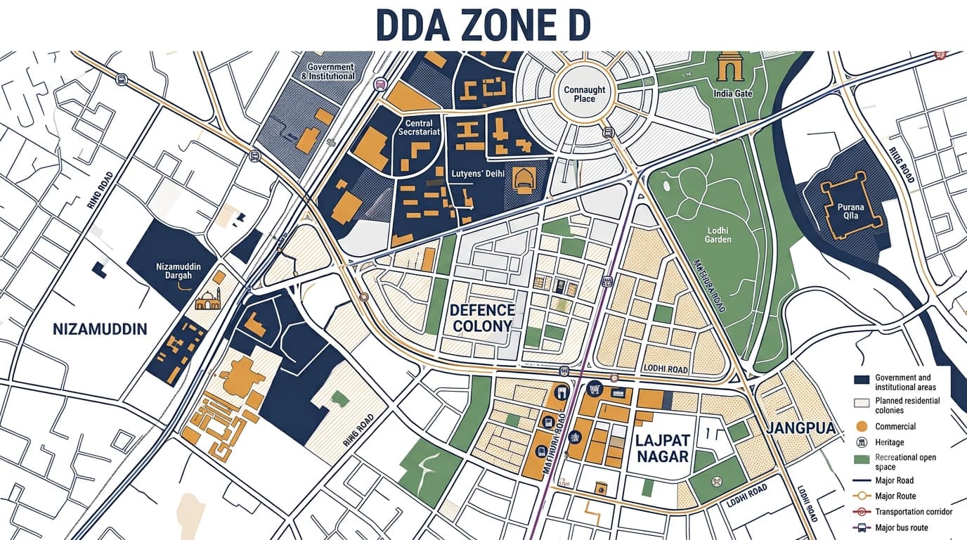
DDA Zone D forms the planning zone of New Delhi and has an area of about 6,855 hectares. It consists of some of the most planned and significant historic cities of Delhi. The zone includes various types of areas ranging from government institutions, business centers, planned residential colonies, heritage centers, recreational areas, and major transport zones. Contrary to the more dense nature of Zone A or the combined nature of residential and commercial areas in Zone B, Zone D has the nature of government institutions, planned residential and central city planning. Some of the important examples of zones within this planning zone include Nizamuddin, Jangpura, Lajpat Nagar, Defence Colony, India Gate and Connaught Place. However, in the study of property, it is important to not only consider the name of the locality but also other factors.
DDA Zone D at a Glance
For a broader understanding of Delhi's planning structure, DDA Zonal Development Plan information can be studied alongside the individual zone pages.
DDA Zone D Areas and Localities
The official DDA planning material identifies Zone D with areas including Nizamuddin, Kilokari, India Gate, Connaught Place, Mata Sundari and Purana Qila. DDA's Zone D layout records also contain planned pockets and layouts in areas such as Defence Colony, Jangpura, Lajpat Nagar and Vinobha Puri.
These localities should not be treated as having identical development rules. A property can be affected by its exact pocket, road, use category, layout plan or special planning controls.
Key Characteristics of DDA Zone D
The planning character of Zone D is different from many peripheral Delhi zones. Its major characteristics include:
Government and institutional development: The zone contains major government and institutional areas associated with New Delhi's administrative role.
Central commercial activity: Connaught Place functions as a major commercial centre within the wider planning area.
Planned residential colonies: Defence Colony, Jangpura, Lajpat Nagar and Nizamuddin contain established planned residential development.
Heritage and historic assets: India Gate, Purana Qila and other historically significant areas contribute to the zone's planning sensitivity.
Large recreational spaces: Parks, gardens, sports facilities and landscaped areas form an important part of the planned urban structure.
Major transportation corridors: The zone is connected by important roads, metro corridors and other city-level transport infrastructure.
Redevelopment potential: Several established areas have undergone or may require redevelopment, modification or layout-level planning over time.
Strong planning controls: Central government, institutional, heritage and recreational areas can have different development considerations from ordinary residential plots.
DDA Zone D Land Use
The DDA Zone D land use structure contains several major categories rather than one dominant use. The official zonal plan identifies residential, commercial and other urban land-use categories.
This is why searching only for DDA Zone D Land Use is not enough when evaluating an individual property. The exact plot or pocket needs to be matched with the applicable planning record.
DDA Zone D Zonal Development Plan
The DDA ZDP of Zone D represents the larger planning context within which New Delhi exists. The zone features an identifiable planned urban configuration based on government function, commerce, recreation, major roads, and established residential pockets.
According to the planning documents of DDA, New Delhi is a planned capital region with major government, commerce and recreation elements. The planning context also emphasizes the significance of large open spaces and the association between major landmarks and the urban form of the city.
In analyzing the DDA ZDP, pay particular attention to:
Land use designation as currently and proposed
Residential pockets
Commercial pockets
Government/Institutional pockets
Major road corridors
Recreational open space pockets
Heritage sensitive pockets
Proposals for modification/redevelopment
Association with the relevant Master Plan requirements
For comparison with other planning areas, readers can also review DDA Zone A, DDA Zone B and DDA Zone C.
DDA Zone D Layout Plans and Sub-Areas
DDA maintains several Zone D layout records. These provide a more detailed view than the broad zonal map.
These layout references show why DDA Zone D Map research should ideally be followed by pocket-level verification rather than relying only on a general locality name. DDA's current layout records list these Zone D plans separately.
Property Verification in DDA Zone D
For buyers, sellers, investors and property professionals, DDA Property Verification becomes especially important in established areas where properties may have older documentation, modifications or redevelopment history.
A practical verification sequence is:
Identify the exact property and plot/site details.
Match it with the relevant Zone D layout.
Check the applicable land-use designation.
Verify ownership and title documents.
Review construction and approval records.
Check applicable road, heritage or redevelopment restrictions.
Take professional legal advice before completing a transaction.
Redevelopment and Planning Considerations
The Zone D has many urbanized zones, and thus it would make sense to consider redevelopment rather than greenfield development. Older residential zones can undergo reconstruction or redevelopment, whereas commercial and institutional areas can be influenced by any change in the planning regulations. In addition, central locations could have additional restrictions owing to their connection to government buildings, heritage, main roads, and recreation zones.
In this regard, the DDA Land Use in Delhi could serve as a guide while comparing a particular property to the overall planning classification. Delhi Master Plan 2047 can be taken into account in the context of the larger planning debate; however, in the end, a particular property should be judged according to the current official plans.
DDA Zone D Compared With Other Zones
This comparison also helps prevent confusion between similarly searched terms such as DDA Zone D Delhi, DDA Zone D Map, DDA New Delhi Zone and DDA Zone D Land Use.
DDA Land Pooling Policy and Zone D
DDA Land Pooling Policy applies more directly to land-pooling sites in Delhi, rather than the central areas in Zone D. This is because the urban form in Zone D is very different from the peripheral planning zones where large sites could be acquired for development. Hence, the issue of land pooling cannot be assumed on the sole basis that the property belongs to the DDA planning zone.
Different Property Situations in Zone D
Common Mistakes to Avoid
Assuming every property in a locality has the same land-use status.
Relying only on a Google Maps locality name instead of the official planning record.
Treating a general DDA Zone D map as a substitute for a property-level layout.
Ignoring older title or allotment documents.
Assuming redevelopment automatically means additional construction is permitted.
Confusing a commercial market area with unrestricted commercial use.
Ignoring heritage, road or special planning restrictions.
Buying land based only on claims about future planning changes.
FAQs
What is DDA Zone D?
DDA Zone D is the New Delhi planning zone, covering approximately 6,855 hectares. It includes important government, commercial, residential, institutional, recreational and heritage-related areas.
Which areas come under DDA Zone D?
DDA identifies areas such as Nizamuddin, Kilokari, India Gate, Connaught Place, Mata Sundari and Purana Qila within Zone D. Its layout records also cover Defence Colony, Jangpura, Lajpat Nagar, Vinobha Puri and other planned pockets.
What is the main character of DDA Zone D?
Zone D has a strong New Delhi planning character, combining government and institutional areas with major commercial centres, planned residential colonies, recreational spaces and heritage locations.
How can I verify a property in DDA Zone D?
Start with the exact plot, site or pocket details and compare them with the applicable DDA layout and land-use records. Then verify ownership, approvals, construction status and any applicable special restrictions.
Is land pooling applicable to all properties in Zone D?
No. Land pooling is not automatically applicable to every property simply because it falls within a DDA planning zone. The exact land-use designation and applicable policy need to be checked.