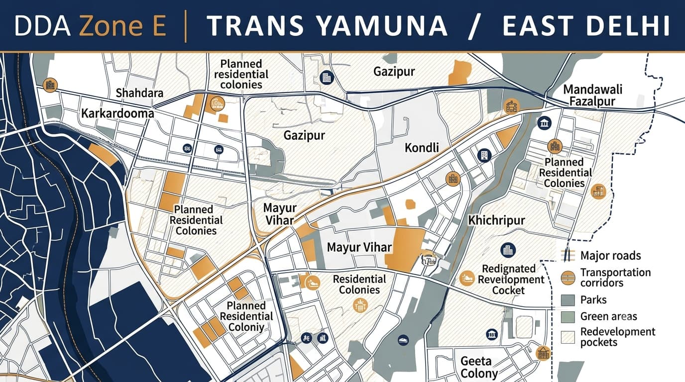
DDA E Zone Delhi Plots Map Use & ZDP
DDA Zone E covers the Trans-Yamuna area of East Delhi and is one of the larger planning zones in the city, covering approximately 8,797 hectares. The zone includes established residential colonies, group housing developments, commercial centres, industrial pockets, institutional areas, transport corridors and several planned and resettlement areas. The character of this zone is different from the central-city planning pattern of DDA Zone D. Zone E has a much broader East Delhi urban structure, with large residential concentrations and planned development around areas such as Shahdara, Karkardooma, Gazipur, Mayur Vihar, Gharoli and Kondli. For property research, the locality name alone should not be treated as proof of land use or development rights. The exact plot, pocket, layout, land-use designation, ownership documents and applicable planning controls should be checked before making a property decision.
DDA Zone E at a Glance
DDA's current planning pages identify Zone E as East Delhi, with examples including Gazipur, Karkardooma, Shahdara, Gharoli and Kondli.
DDA Zone E Areas and Localities
The Trans-Yamuna planning area contains a wide range of established and planned development. DDA's layout and screening records also show planning activity in locations such as Mayur Vihar, Mandawali Fazalpur, Geeta Colony, Khichripur, Vivek Vihar, Jhilmil, Shahdara and Kondli Gharoli.
These locations should not be considered interchangeable. The applicable planning controls can vary considerably between a residential pocket, commercial centre, institutional site and industrial area.
Key Characteristics of DDA Zone E
The planning identity of Zone E is closely linked to the growth of East Delhi. Its major characteristics include:
Large residential concentration: Planned colonies, group housing, resettlement areas and established residential pockets form a major part of the zone.
Mixed urban development: Residential areas exist alongside commercial, institutional and service-oriented uses.
Major commercial centres: Karkardooma and Shahdara contain important commercial and service activity.
Industrial pockets: Parts of the zone contain industrial areas, including locations around Jhilmil, Tahirpur and the Shahdara corridor.
Transportation infrastructure: Major roads and regional connections play an important role in the development pattern.
Institutional facilities: Schools, hospitals, community facilities and other public/semi-public uses are distributed across planned pockets.
Planned group housing: Mayur Vihar and surrounding areas include significant planned group-housing development.
Resettlement development: Several areas have evolved through planned resettlement and rehabilitation schemes.
Ongoing planning modifications: DDA layout and land-use records show modifications and utilization plans for different pockets over time.
DDA Zone E Land Use
The DDA Zone E Land Use framework includes several categories. DDA's Zone E planning map identifies residential, commercial, industrial, recreational, transportation, utility, government, public and semi-public uses, along with agriculture/green-belt and water-body categories.
This makes it important to distinguish between DDA Zone E Map, DDA Zone E Land Use and an individual property's actual planning status.
DDA Zone E Zonal Development Plan
The DDA Zone E Zonal Development Plan provides the broader planning framework for the Trans-Yamuna area. DDA records describe Zone E as a large area across the Yamuna and divide it into 21 sub-zones. The planning framework incorporates planned colonies, unauthorised but regularised colonies, urban and rural villages, resettlement colonies and other planning considerations.
When studying the DDA Zonal Development Plan, focus on:
Residential and group-housing areas
Commercial and service centres
Industrial pockets
Institutional and public/semi-public facilities
Major transportation corridors
Recreational and green areas
Resettlement and rehabilitation areas
Village and existing built-up areas
Proposed or modified layouts
Land-use changes affecting individual pockets
The ZDP should be read together with the applicable land-use and layout records rather than being treated as a standalone property document.
DDA Zone E Layout Plans and Planning Pockets
DDA's current layout records contain numerous Zone E plans, showing how detailed planning operates below the broad zonal level.
The presence of an area in a DDA layout record does not by itself establish the legal status of every property inside that area. Individual property documentation still needs to be verified.
Property Verification in DDA Zone E
Because Zone E contains several types of development, DDA Property Verification should be performed at the property and plot level.
A practical verification sequence is:
Identify the exact property, plot, pocket or society.
Match it with the relevant Zone E layout.
Check the applicable land-use designation.
Verify ownership and title documents.
Check building or development permissions.
Review road, access and facility reservations.
Check any applicable land-use modifications.
Obtain professional legal advice before completing a transaction.
Residential and Group Housing Development
One of the important characteristics of Zone E is its concentration of planned residential development. Mayur Vihar, Vivek Vihar and other parts of East Delhi contain planned housing layouts and group-housing developments. For apartments, the research process can differ from that of an independent plot. Buyers may need to examine the society or group-housing layout, land ownership, sanctioned plans, common areas, access roads and applicable permissions. This is why a search for DDA Zone E Areas should eventually move from the broad zone level to the exact residential pocket or project.
Commercial and Industrial Planning
Zone E also has important commercial and industrial components. Gazipur has planning records associated with commercial and industrial activity, while Shahdara and Jhilmil contain established employment and industrial-related areas. DDA records also include planning activity around Integrated Freight Complex Gazipur and industrial areas around the Shahdara corridor. For commercial or industrial property, buyers should therefore verify the specific designated use instead of assuming that commercial activity visible on the ground automatically means unrestricted commercial or industrial use.
Redevelopment and Planning Considerations
Zone E has evolved through multiple phases of planned development, resettlement, group housing, commercial growth and infrastructure expansion. This creates different planning situations within the same zone. An established residential colony may have redevelopment considerations, while an industrial pocket may be governed by a different land-use framework. Similarly, a vacant parcel near a developed colony should not automatically be assumed to have the same development rights as surrounding properties.
The DDA Land Use in Delhi framework is therefore useful when researching a property, but the final assessment should be based on the applicable official record for that particular site. The Delhi Master Plan 2047 can be considered for the broader future planning context, while property decisions should remain based on the applicable current planning and legal documents.
DDA Zone E Compared With Other Zones
This comparison helps distinguish DDA Zone E Delhi from other DDA planning zones that may appear in similar property searches.
DDA Land Pooling Policy and Zone E
The DDA Land Pooling Policy should not automatically be applied to every property within Zone E. Zone E contains extensive existing urban development, including planned colonies, group housing, commercial areas, industrial pockets and resettlement areas. Where a property is being evaluated in relation to land pooling, the exact parcel, planning designation and applicability of the relevant policy must be established first. This is particularly important because a property being located within the wider DDA planning framework does not by itself establish eligibility under a particular development policy.
Different Property Situations in Zone E
Common Mistakes to Avoid
Assuming every East Delhi locality has the same land-use classification.
Treating the locality name as proof of development rights.
Using only a broad DDA Zone E Map without checking the relevant layout.
Assuming an existing commercial activity automatically means commercial land use.
Ignoring industrial-use restrictions in designated industrial pockets.
Failing to verify group-housing or society-level documents.
Ignoring road alignments and facility reservations.
Assuming every vacant parcel can be developed like neighbouring residential plots.
Treating future planning proposals as existing development permissions.
FAQs
What is DDA Zone E?
DDA Zone E is the Trans-Yamuna or East Delhi planning zone. DDA planning documents place its area at approximately 8,797 hectares and divide the zone into 21 sub-zones.
Which areas come under DDA Zone E?
Important areas identified in DDA planning and layout records include Gazipur, Karkardooma, Shahdara, Gharoli, Kondli and Mayur Vihar, along with several other residential, commercial, industrial and institutional pockets.
What is the main character of DDA Zone E?
Zone E has a broad East Delhi planning character, with large residential concentrations alongside commercial centres, group housing, industrial pockets, institutional facilities, transportation infrastructure and resettlement areas.
Is Mayur Vihar part of DDA Zone E?
DDA's Zone E layout records include planning and group-housing layouts associated with Mayur Vihar Phase I, II and III, making it an important reference area when studying the zone.
How can I verify a property in DDA Zone E?
Start by identifying the exact plot, pocket, society or site. Then match it with the applicable DDA layout and land-use designation before checking ownership, approvals, construction status and other restrictions.
Is land pooling applicable to every property in Zone E?
No. Land pooling does not automatically apply to every property simply because it falls within Zone E. The property's exact planning status and the applicability of the relevant policy must be verified.