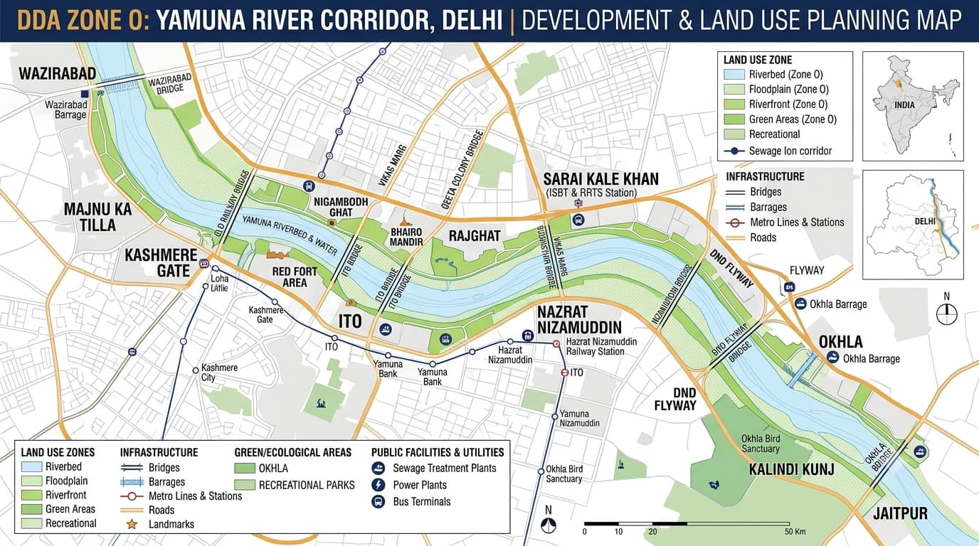
DDA Zone O, officially called the River Yamuna / River Front Zone, is a zone through which the river Yamuna flows in Delhi from north to south. In contrast to most other DDA planning zones, Zone O is mainly determined by the river, the floodplain of the river, river front, ecological systems, embankments, open spaces, and recreational and water-based facilities. Presently, the list of DDA planning zones includes DDA O Zone, which is 15,707 hectares. The zone is located on the Yamuna Corridor, and among the significant landmarks of Zone O are Wazirabad Barrage, ITO Barrage, Old Railway Bridge, Nizamuddin Bridge, Okhla Barrage, Kalindi Kunj and Jaitpur. When it comes to the DDA O Zone Map, the key issue is the difference between the riverbed, floodplain, and riverfront. Zone O should not be understood as a conventional residential zone. Its planning priorities are closely connected with the Yamuna's ecological and hydrological functions. The Yamuna enters Delhi from the north near Palla, passes through the city from north to south and leaves the National Capital Territory near Jaitpur. The Zone O planning geography follows this river corridor. Major geographic reference points include: Wazirabad Barrage Old Railway Bridge ITO Barrage Nizamuddin Bridge DND Flyway Okhla Barrage Kalindi Kunj Jaitpur Eastern and western marginal embankments Floodplain areas on both sides of the river This distinction is essential when reading a Delhi Zone O Map because land immediately next to the river does not necessarily have the same planning status as land farther from the active river channel. Because Zone O follows the Yamuna rather than a conventional set of neighbourhood boundaries, it is better to understand it through major river corridors, bridges, barrages and adjoining areas. The land-use pattern of Zone is substantially different from zones dominated by residential development. A major point is that land-use designation in Zone cannot be interpreted in the same way as a normal residential or commercial zone. Environmental and floodplain considerations are central to development decisions. This is one of the crucial things to keep in mind when working with Zone O. The riverbed means the water course itself, along with everything associated with the river hydrological system. Development within the riverbed is totally different from the development on regular urban lands. The floodplain means the area, which can be affected by the river floods and which plays a significant role in the functioning of the river natural hydrological system. Riverfront is the areas, which lie beyond the context of the active floodplain/embankment and where carefully thought public, recreational, ecological or infrastructure-related uses might be envisaged. The floodplain is one of the key elements of the planning in Zone O. The floodplain serves many purposes: It allows accommodating the high levels of water in the river system. Groundwater recharge. Ecological function. Riparian vegetation. Natural open space. Maintaining the river hydrological system. That is why the planning strategy for Zone is based on conservation, ecological restoration and controlled development. The Yamuna corridor contains important ecological landscapes and green areas. Planning and riverfront initiatives include: Biodiversity parks Riverfront parks Riparian green areas Nature-based recreational spaces Wetland and water-related landscapes Open spaces along the river Ecological restoration areas Several major riverfront landscape projects are located along different stretches of the Yamuna, including areas between Wazirabad and the Old Railway Bridge, Old Railway Bridge and ITO, and Nizamuddin Bridge and DND Flyway. This northern stretch includes the area around the Wazirabad Barrage, the northern river corridor and the Old Railway Bridge. The surrounding landscape includes major roads, bridges, transport infrastructure, public facilities and established urban development. This stretch forms another important central river corridor and connects major road and bridge infrastructure. This southern-central section includes major ecological and riverfront planning areas and connects the river corridor with eastern and south-eastern Delhi. The southern stretch contains important ecological, recreational and water-related landscapes and eventually connects toward the southern boundary of Delhi. Riverfront development in Zone is not simply about constructing buildings next to the river. A sustainable riverfront planning approach can include: Biodiversity restoration Public parks Walking and cycling spaces Ecological landscapes River-view areas Controlled recreational facilities Water management infrastructure Restoration of natural habitats Zone O also contains infrastructure that supports Delhi's wider urban system. Planning records include references to: Water reservoirs Pumping stations Sewage treatment infrastructure Drainage facilities Gas-related facilities Roads Bridges Transport infrastructure River-related utilities For example, areas around Sarai Kale Khan have been associated with water and sewage infrastructure planning. Although the Zone is primarily a river corridor, transportation infrastructure crosses it at several important points. Major crossings and corridors include: Wazirabad Old Railway Bridge ITO Nizamuddin Bridge DND Flyway Okhla Other road and rail crossings The DDA Zonal Development Plan is designed specifically for the River Yamuna and River Front. Its planning approach focuses on: River rejuvenation Ecological conservation Floodplain protection Riverfront development Public recreation Green spaces Transportation Infrastructure Water management Controlled development DDA maintains layout and planning records for different parts. These include planning references for: Madanpur Khadar Shastri Park Extension Sarai Kale Khan Wazirabad Road Marginal Bundh areas Riverfront development pockets Water reservoirs Pumping stations Sewage treatment facilities Burial and cremation facilities Temporary accommodation Other public and infrastructure uses Property located near the Yamuna requires particularly careful verification. Before purchasing land or property in or around the river corridor, check: Exact property location Revenue village and khasra details Applicable DDA planning zone Land-use designation Floodplain status Riverfront or green-area designation Relevant layout plan Road and access status Ownership and title documents Applicable environmental and development restrictions Any proposed infrastructure or road alignment Whether the proposed property use is permitted A general property listing, locality map or road address should not be treated as sufficient verification for land close to the Yamuna.For detailed research, the DDA Property Verification framework should be used along with the applicable land-use and planning records. Zone O interacts geographically with many of Delhi's other planning zones because the Yamuna forms a major natural boundary and urban corridor. This makes Zone O important for understanding the overall geography of Delhi's planning zones. DDA Zone O is the River Yamuna / River Front planning zone of Delhi. It follows the Yamuna corridor from the northern to the southern boundary of the National Capital Territory. Important reference points include Wazirabad, Old Railway Bridge, ITO, Nizamuddin, Sarai Kale Khan, DND Flyway, Okhla, Kalindi Kunj and Jaitpur, along with riverfront and floodplain areas between these locations. It includes river and water areas, floodplain, green and ecological areas, recreation, transportation, utilities, public facilities and other controlled river-related uses. The current DDA planning table lists 15,707 hectares for this planning area. Yes. The river and its associated floodplain form a central part of the planning framework. No. A property's location within or near the area does not automatically establish residential development permission. The applicable land use, floodplain status, layout and development controls must be checked. The floodplain is the area associated with the river's natural flooding and hydrological function, while the riverfront refers to the broader area outside the active floodplain where carefully planned public, ecological, recreational or other permitted uses may be considered. The map can help establish the broader planning context, but property verification requires the exact location, land-use information, relevant layout plans, ownership documents and any applicable environmental or flood-related restrictions.DDA Zone O Map & Land Use
DDA O Zone at a Glance
DDA O Zone Map: Where Is It Located?
Understanding the Three Important River Areas
Delhi Zone O Areas and Locations
DDA Zone O Land Use
Riverbed, Floodplain and Riverfront: What is the difference?
Riverbed
Floodplain
Riverfront
DDA Zone O and Floodplain of the River Yamuna
Ecological and Green Areas
Major Riverfront Areas
Wazirabad to Old Railway Bridge
Old Railway Bridge to ITO
ITO to Nizamuddin
Nizamuddin to DND Flyway
DND Flyway to Okhla / Kalindi Kunj
DDA Zone O and Riverfront Development
Infrastructure and Utility Planning
Transportation Around O Zone
DDA Zonal Development Plan
Zone O Layout Plans
What to Check Before Buying Property
Zone O and Other DDA Planning Zones
FAQs
What is DDA Zone O?
Which areas come under this planning area?
What is the land use of this area?
What is the area covered by the zone?
Is the Yamuna floodplain part of the planning area?
Can residential property be developed anywhere in this area?
What is the difference between the Yamuna floodplain and riverfront?
Can the DDA Zone O Map verify a property?