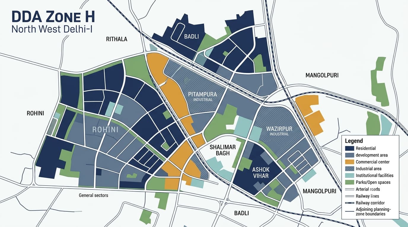
DDA Zone H, which is alternatively referred to as North West Delhi-I, encompasses a significant portion of north west Delhi that includes places like Rohini, Pitampura, Shalimar Bagh, Wazirpur, Badli, and Rithala. It consists of planned residential as well as commercial zones, industrial zones, institutional zones, parks, and urban zones. In its current zone plan, DDA has identified Zone as North West Delhi-I, having an area of 15,178 hectares. On the other hand, the notified Zone-H Zonal Development Plan document under MPD-2021 identifies the area as 5,677 hectares. The area figures should not be treated as interchangeable. For a specific property, the plot-level land use, layout plan and applicable planning record are more important than the headline zone-area figure. DDA Zone H lies in the north-western part of Delhi. Its planning geography is connected with several important railway corridors and adjoining planning zones. The notified Zonal Development Plan describes the broad boundaries as: North-east: Railway line towards Karnal and Zone C Delhi West: Rohini Phase-III and Zone M North-west: Nangloi Drain and Rithala STP, adjoining Zone M South-west: Railway line towards Rohtak and Zone G This makes Zone an important transition area between established north-west Delhi neighbourhoods and larger planned urban areas such as Rohini. The official DDA layout records separately identify a Rohini part area and outside Rohini, showing that the planning structure contains different development patterns rather than one uniform land-use character. Zone H comprises a combination of colonies, urban villages, residential projects, commercial centers, and industrial sectors. Urban villages that are included in the ZDP notification include Wazirpur, Shakurpur, Pitampura, Shalimar Bagh, Shingalpur, Sahipur, Haiderpur, Badli, Naharpur, Rithala, Razapur, Mangolpur Kalan, and Mangolpur Khurd. Rohini is quite significant since Phases I and II of the Rohini project fall within the zone. The Rohini is described as a primarily residential DDA project located on an extensive planned land parcel. Land use in Zone H is not limited to residential development. The planning framework includes residential areas alongside commercial centres, industrial areas, recreational spaces, public and semi-public facilities, transport infrastructure and other supporting uses. An important consideration in property studies is that even when a land use is specified for a particular piece of property in the Zonal Development Plan, it does not necessarily mean that the landowner is automatically entitled to develop it in the specified manner. Residential development is a prominent feature of the area. The planning scheme includes existing colonies of Pitampura, Shalimar Bagh and Ashok Vihar, apart from the extensive Rohini colony. The layout plan of the DDA has several residential layouts for Rohini sectors/pockets as well as Pitampura, Shalimar Bagh and Wazirpur/Ashok Vihar. But when doing research on a property, just knowing the name of the area is not sufficient. A property should be verified in relation to its: Plot or property location Layout plan Land-use designation Sub-zone or planning area Road width and access Applicable development controls Building permissions Ownership and title documents This is where DDA Property Verification becomes important before treating a property as suitable for a particular use. The Netaji Subhash Place and Manglam Place have been notified as important places for commercial activities like shopping, offices, and healthcare within the ZDP. There are also mixed use and commercial roads that have been notified within the ZDP. The ZDP notification has classified the mixed use roads in the areas of Rani Bagh, Rishi Nagar, Raja Park, Shastri Nagar, Tri Nagar and Rohini. Since the classification is purely planning-related, one cannot consider any commercial activity permitted just on the basis of commercial activity in an area. Industrial development is another defining feature of Zone H. Major planning references include: Wazirpur Industrial Area Lawrence Road Industrial Area Mangolpuri Industrial Area Industrial and service-related pockets Areas connected with manufacturing, repair and other permitted activities There is also a great deal of provision for recreation and greenspace planning. According to the notified ZDP, there is an identification of district parks, sport grounds, picnic sites, orchards, and other green areas in this district. Shalimar Bagh stands out here because it is noted that Shalimar Bagh is a protected forest and also a historical garden of the Mughal era. Sports facilities provided by DDA can be found in this zone around places like Rohini and Ashok Vihar. The DDA Zone H Zonal Development Plan provides the planning framework for the area. It covers more than a simple land-use map and includes provisions relating to: Residential development Commercial activity Industry Social infrastructure Health and education Sports facilities Road and railway circulation MRTS corridors Parking Open spaces Protected forest areas Water bodies Physical infrastructure Proposed land use and changes in land use The notified Zone-H ZDP was approved by the Central Government in March 2010 under the MPD-2021 framework. You can also refer to the DDA Zonal Development Plan to understand how Zone H fits within Delhi's wider zone-wise planning structure. The Zone layout records are particularly useful when researching an individual property because they move from broad zonal planning toward more detailed development layouts. DDA records include layouts for: Rohini sectors and pockets Pitampura residential schemes Shalimar Bagh blocks Wazirpur/Ashok Vihar Lawrence Road Industrial Area Wazirpur Industrial Area Mangolpuri Industrial Area Service centres Commercial and facility plots For example, the DDA layout database separately lists Rohini sector plans and detailed layouts for Pitampura, Shalimar Bagh, Wazirpur and industrial areas.This distinction matters because a zone-level map cannot replace a detailed layout plan when checking a specific plot. A locality being included in Zone H does not by itself confirm that every property within it has the same permitted use. Before purchasing or developing property, check: Exact property location and plot details Ownership and title documents Applicable land-use designation DDA layout plan Sub-zone or sector Road width and access Building and development controls Whether the proposed use is permitted Any applicable mixed-use or commercial-street notification Current status of approvals and permissions This is especially important in areas where planned colonies, urban villages, mixed-use streets and industrial pockets exist close to one another. Zone H connects with several other DDA planning zones, including Zone C toward the north-east, Zone G toward the south-west and Zone M toward the west/north-west. Understanding these adjoining zones can make the DDA map easier to interpret because planning boundaries do not always follow the everyday boundaries people use for localities. For a broader comparison, readers can also explore: DDA Zone C Delhi DDA Zone G Delhi DDA Zone M DDA Zonal Development Plan Delhi Master Plan 2047 These links should be placed contextually where the reader needs additional planning information rather than grouped as promotional links. DDA Zone H is known as North West Delhi-I. It covers a broad planning area containing Rohini, Pitampura, Shalimar Bagh, Wazirpur, Badli, Rithala and other surrounding areas. Major areas associated with it include Rohini, Pitampura, Shalimar Bagh, Wazirpur, Ashok Vihar, Mangolpuri, Badli and Rithala, along with several urban villages and planned residential areas. The planning area contains multiple land-use categories, including residential, commercial, industrial, institutional, recreational and transport-related uses. Yes. The notified planning document identifies parts of the Rohini project within this area, and DDA maintains separate layout-plan records for the Rohini part. The zone map is a useful starting point, but it should not be the only verification document. A property should also be checked against the relevant layout plan, land-use designation, ownership documents and applicable development controls. DDA's current planning page lists 15,178 hectares, while the notified Zone-H Zonal Development Plan document states 5,677 hectares. Because the two official records differ, the figure should be identified by source and date when used for research.DDA Zone H Map & Land Use
DDA Zone at a Glance
DDA Zone H Map: Where Is It Located?
Main Areas Associated With This Zone
DDA H Zone Areas and Localities
DDA H Zone Land Use
Residential Development
Commercial Areas and Mixed-Use Development
Industrial Areas in Zone
Parks, Green Areas and Recreational Planning
DDA Zone H Zonal Development Plan
DDA H Zone Layout Plans
What to Check Before Buying Property in Zone H
Zone H and Delhi's Wider Planning Structure
FAQs
What is DDA Zone H?
Which areas come under this planning area?
What is the land use of this area?
Is Rohini part of this planning area?
Can I verify a property using the DDA Zone H map?
What is the area covered by DDA Zone H?