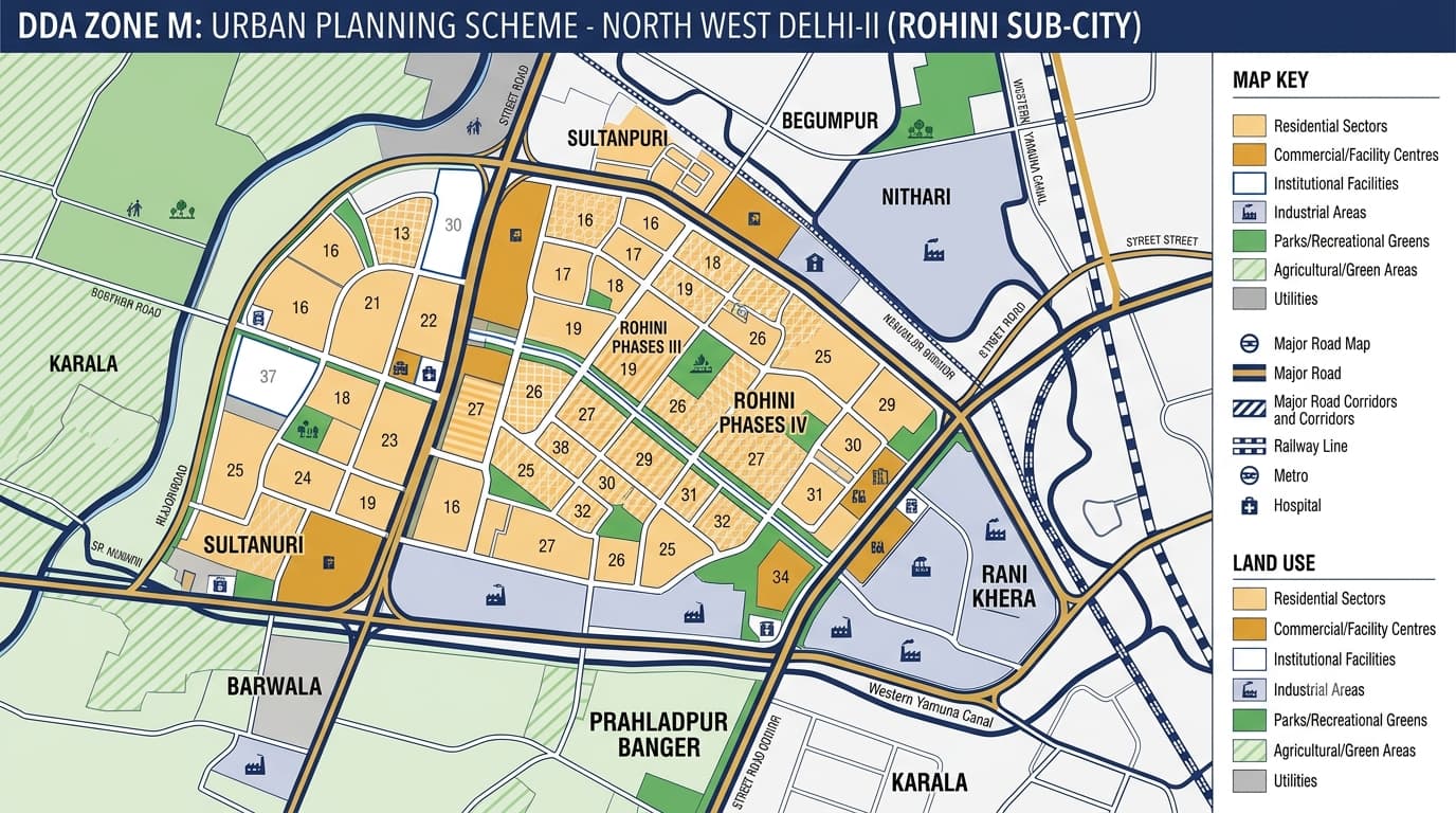
The official designation in DDA’s present zonal plan table is North West Delhi-II for DDA M Zone. This zonal region is well-known for the Rohini Sub-City and consists of large scale planned sectors which include residential areas, commercial nodes, institutional, industrial zones, roadways and green areas. Present DDA’s zonal plan page describes the total land area to be 15,851 hectares. The earlier planning documents give information about smaller planning components individually such as the Rohini Phase III, IV and V area. Therefore, the present DDA zone level figure for the zonal region should be considered as 15,851 hectares. Zone M is located in the northwest of Delhi, where the planning aspect of this zone has some connection with the proposed expansion of Rohini. The old notifications on the planning aspect of this region mention the region surrounding Rohini Phases III, IV & V, whose major geographic features include the Western Yamuna Canal, railway lines, major roads, and adjacent planning zones. The map of Zone from the DDA includes links to Narela Sub-City, Khera Kalan, Khera Khurd, Siraspur, Libaspur, Badli, Haiderpur, Rithala, and Pitampura. The key geographic references for understanding the DDA Zone M Map are: Rohini planned sectors Rohini Phases III, IV and V Sultanpuri Begumpur Nithari Barwala Prahladpur Banger Rani Khera Karala Madanpur Dabas Mohammadpur Majri Parts of Khera Khurd DDA records show a broad mix of planned and existing settlements associated.. The land-use structure of Zone is broader than residential development alone. This means a DDA Zone M Land Use Map should be read at more than one level. The broad zone identifies the planning context, while detailed sector and layout plans provide more useful information for a particular property. The strongest planned-development identity of Zone M comes from Rohini. DDA's layout records contain detailed plans for numerous Rohini sectors, including: Sector 20–22 Sector 23 Sector 24 Sector 25 Sector 26 Sector 27 and 28 Sector 29 Sector 30 Sector 31 Sector 32 Sector 34 and 35 Sector 36 and 37 Sector 38 Sector 39 Sector 40 Sector 41 The DDA also has separate records for Rohini Phase III, IV and V, apart from the records of layouts related to industries and facilities. New records in the DDA layout database include Rohini sectors which have been proposed or modified, such as Sector 26, Sector 29, Sector 32, Sector 34, Sector 37 and Sector 38. Use of residences constitutes an important part of the Rohini development scheme. The DDA layout database includes records of residential pockets, alternative plots, group housing plans, facilities and other related layouts in Rohini phases. Commercial development in Zone M is supported by facility centres, local shopping areas and other designated commercial uses. The planning structure also includes facilities such as: Local shopping centres Community facilities Schools Hospitals Sports facilities Police and fire services Religious and socio-cultural facilities Other public and semi-public uses The actual permitted use of a particular plot should still be checked against its applicable layout and planning designation. Industrial development is also present within the wider Zone-M planning structure. DDA's Rohini layout records include a Rohini Industrial Area and planning for an industrial area around the later Rohini phases. The Zone-M map also identifies infrastructure and utility uses associated with the planned development. Green and recreational areas are incorporated into the planned development framework. The Rohini Zone-M land-use map identifies green belt/agricultural green and water-body categories, while the sector-level planning structure includes parks and recreational facilities. The DDA Zone M Zonal Development Plan serves as the planning basis that links the Delhi Master Plan 2047 to the layout planning. At present, the DDA MPD-2021 Zonal Development Plan webpage has listed Zone M having a report and map. With regards to the Rohini area, the planning document of the DDA has listed the land use types, sector limits, road widths, railway lines, utility services and semi-public/ public facilities. DDA maintains a substantial collection of Zone-M layout records. These include: Rohini sector layouts Residential pockets Alternative plot layouts Industrial-area layouts Community facilities Public and semi-public facility sites Utility infrastructure Sector modifications Vacant-land utilisation plans The current DDA layout database specifically lists Rohini M Zone sector plans from Sector 20 through Sector 41, along with separate North-West Delhi-II and North-West Delhi-III references. Roads and Transportation in Zone M Transportation is an important part of the Zone-M planning structure. The Rohini planning map shows major road rights-of-way, including 100 m, 60 m, 45 m, 30 m and 24 m corridors, together with railway lines and other circulation infrastructure. The map also identifies: Western Yamuna Canal Railway line toward Rohtak Railway line toward New Delhi NH-10 / Rohtak Road references Major sector roads Utility corridors Drainage infrastructure For property research, the actual road shown in the approved layout should be checked rather than relying only on a general locality map. Exact property location Sector, pocket and block Revenue village and khasra details Ownership and title documents Applicable land-use designation Relevant DDA layout plan Road width and access Building and development controls Current permissions and approvals Whether the proposed use matches the designated use This is particularly important in areas where planned Rohini sectors, villages, industrial pockets, green areas and infrastructure corridors occur close to one another. For broader planning research, readers can also refer to DDA Land Use in Delhi, DDA Property Verification, and the DDA Zonal Development Plan. Zone M sits within a wider north-west Delhi planning network. Some villages cross planning-zone boundaries. For example, DDA records show parts of Karala, Rani Khera, Madanpur Dabas, Mohammadpur Majri and Khera Khurd associated with Zone M in DDA land pooling related records. DDA Zone M is currently listed as North West Delhi-II. It is strongly associated with the Rohini Sub-City and includes planned residential sectors along with commercial, institutional, industrial, recreational and infrastructure uses. Important areas and planning references include Rohini, Sultanpuri, Begumpur, Nithari, Barwala, Prahladpur Banger, Rani Khera, Karala, Madanpur Dabas and Mohammadpur Majri, although some areas may be divided between different planning zones. Major parts of Rohini, particularly the planned later phases and sectors, are represented in DDA's layout and planning records. The exact phase and sector should be checked for a specific property. The planning area contains residential, commercial, public and semi-public, industrial, recreational, green/agricultural, utility and transportation-related land uses. DDA's current zonal-plan table lists 15,851 hectares for North West Delhi-II. Older documents may describe smaller components or specific Rohini phases separately. The map can help identify the broader planning context, but property verification requires the relevant layout, land-use designation, plot details, ownership documents and applicable development controls.DDA Zone M Delhi
DDA Zone M at a Glance
DDA Zone M Map: Where Is It Located?
DDA M Zone Areas and Localities
DDA Zone M Land Use
Rohini Development
Residential Development
Commercial and Facility Development
Industrial Areas
Parks, Green Areas and Open Spaces
Zonal Development Plan
DDA Zone M Layout Plans
What to Check Before Buying Property
Zone M and Adjoining Planning Areas
FAQs
What is DDA Zone M?
Which areas come under this planning area?
Is Rohini part of this planning area?
What is the land use of this area?
What is the area covered by DDA Zone M?
Can the DDA Zone M map verify a property?