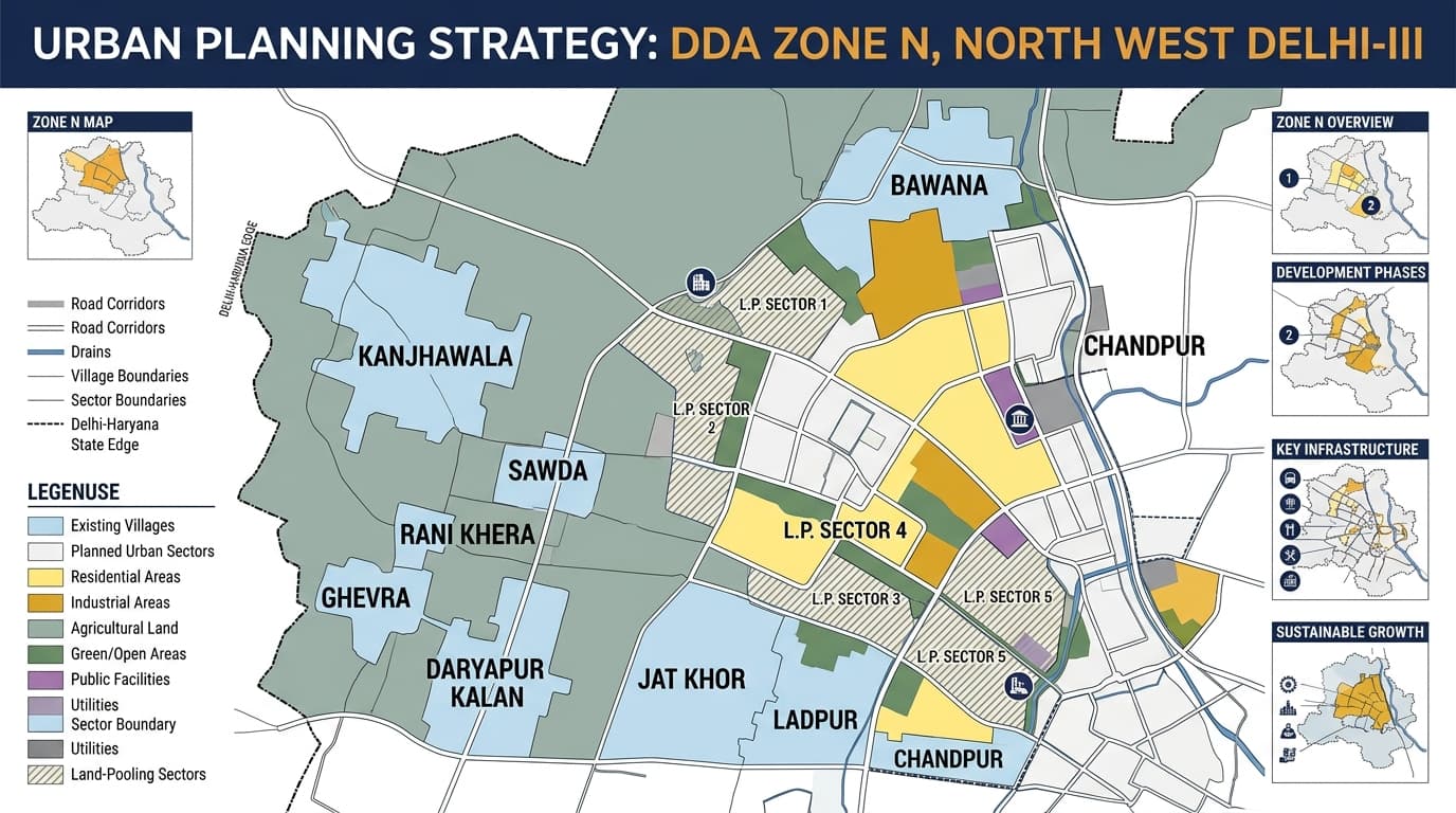
The DDA Zone N, which is officially designated as North West Delhi-III, is a large planning area located in the northwest and outer part of the city of Delhi. Notable areas related to the planning area include Bawana, Kanjhawala, Sawda, Rani Khera, Ghevra, Rasulpur, Daryapur Kalan, Jat Khor, Ladpur, Chandpur and Khera Khurd. This zonal area differs significantly from the highly populated residential areas located in the central and inner parts of Delhi. Some of the main elements include planned urban expansion, land pooling areas, villages, agricultural land, residential zones, industries, greenspaces and transportation routes. The latest planning map by the DDA refers to N Zone as North West Delhi-III. However, the Zonal Development Plan, which has been notified earlier, applies to an area of 13,975 hectares. The zone should be understood as a large planning area rather than one uniform locality. Different villages, sectors and development parcels can have different land-use and planning conditions. Zone N is located towards the north-west side of Delhi and extends up to the outer periphery of the city towards Delhi-Haryana borders. The planning geography of Zone comprises of Kanjhawala, Bawana, Sawda, Rani Khera and Ghevra with links to other planning zones such as Zone M, Zone P-I, Zone L and Zone J. The broader map contains a combination of: Existing villages and settlements Planned urban sectors Agricultural and green areas Land-pooling sectors Industrial and employment-related areas Major roads Drains and water-related features Utility infrastructure Proposed urban development areas This makes the Delhi N Zone Map particularly useful for understanding where planned development is expected in relation to existing villages and agricultural land. The planning area contains several villages and settlements, and some villages are divided between Zone N and adjoining zones. The exact DDA zone for a property should not be assumed from the village name alone because some villages extend across planning-zone boundaries. The Zone has a broad and varied land-use structure. Unlike a compact urban zone dominated by existing residential colonies, this area contains substantial agricultural, green, urbanisable and planned-development land alongside residential, commercial, industrial and public facilities. The presence of agricultural or open land does not automatically mean that the land can be converted into residential or commercial property. The applicable land-use designation and development framework must be checked first. Residential development in the Zone includes both existing village settlements and planned urban expansion. For property research, the locality name is only the starting point. A buyer or investor should also examine: Exact plot location Revenue village Khasra number Existing land use Proposed land use Sector or land-pooling sector Layout plan Road access Ownership documents Development permissions Land pooling becomes especially important while undertaking studies on Zone N. The zone has many land pooling sectors, which have been marked on the map by DDA, giving the numbers of sectors and lands within those sectors. In this land pooling system, private lands become a part of a joint development plan, not individual projects. Zone N land-pooling maps include areas around: Kanjhawala Sawda Rani Khera Ghevra Rasulpur Madanpur Dabas Daryapur Kalan Other surrounding villages and sectors Therefore, the land-pooling sector map will differ from the simple DDA Map. While the former helps in understanding the planning boundary, the latter offers more details on sectors, villages, and pooled lands. It is advisable for researchers to use the DDA Land Pooling Policy in connection to the information at the zoning level. Bawana is a development reference point in relation to the larger Zone N planning area. Bawana is related to industrial development and planned infrastructure development. Thus, Bawana is distinct from agricultural and villages that make up the rest of the zone. Industrial planning may consist of: Manufacturing areas Warehousing and service activities Industrial plots Supporting commercial uses Transport infrastructure Worker and residential support facilities However, an existing industrial activity does not automatically establish that every nearby parcel has industrial land use. The specific plot and applicable planning document must be checked. Kanjhawala is another important geographic reference for Zone N. Its location illustrates the transitional character of the zone, where existing village settlements are surrounded by agricultural land, proposed urban sectors and large-scale infrastructure planning. The area is particularly relevant when studying: Land-pooling sectors Proposed urban development Road networks Village boundaries Agricultural land Residential expansion Connectivity toward outer Delhi Several settlements in the western and north-western portion of this Zone form part of the broader urban-expansion landscape. Sawda is associated with settlement development and planned urban expansion. Its position within the outer Delhi planning framework makes the exact land-use designation important for property research. Rani Khera is a village and peripheral development area. Parts of the wider village/planning area have connections with adjoining planning zones, so exact parcel-level verification is important. Ghevra forms part of the western side of the Zone N planning geography and is associated with village, industrial and land-pooling-related development. These areas should not be treated as identical simply because they appear within the same broad DDA planning zone. Green and agricultural land is an important part of the Zone. A vacant parcel may be: Agricultural land Green Belt Government land Gram Sabha land Land included in a planned sector Land affected by a proposed road Utility land Land under another planning designation Therefore, vacant land should never be treated as automatically developable land. The DDA Zonal Development Plan provides the planning framework for North West Delhi-III. The plan connects the broader Master Plan with more detailed planning and layout proposals. It covers land-use distribution and supporting infrastructure across a large and diverse geographical area. Key planning components include: Residential development Commercial areas Industrial areas Recreational land Public and semi-public facilities Transportation Utilities Green areas Agricultural land Government land Urban expansion areas The Zonal Development Plan should be treated as a planning document, not as proof of ownership or development permission for an individual property. The detailed sector and land-pooling maps become especially useful. Current DDA planning records include sector-based maps around areas such as Kanjhawala, Sawda and Rani Khera, with sector numbers shown across the planning area. These maps can provide information about: Sector boundaries Village boundaries Khasra parcels Pooled land Government and Gram Sabha land Roads Drains Johads/water features Unauthorized-colony references Adjacent planning zones For a property located within a land-pooling area, the sector number and parcel details can therefore be more useful than simply knowing that the property falls in Zone N. The planning structure includes: Major arterial roads Sector roads Village roads Road reservations Railway-related infrastructure Drains and utility corridors Connections toward Haryana Links to surrounding DDA planning zones The exact road alignment is particularly important when evaluating land in developing sectors because a proposed road or right-of-way can affect the usable portion of a parcel. Zone N contains a mixture of developed settlements, agricultural land, villages, planned sectors and land-pooling areas. Because of this, property verification should be more detailed than simply checking the locality name. Before purchasing or developing property, verify: Exact location of the property Revenue village Khasra number Ownership and title documents Current land use Proposed land use Applicable DDA zone Land pooling policy, where applicable Road alignment and access Relevant layout or sector plan Development permissions Any restrictions affecting the parcel For land-pooling properties, also check whether the parcel is actually included in the applicable planning sector and what status applies to the land. Zone N is connected with several other planning areas. The exact boundary should always be taken from the relevant DDA zonal or sector map instead of assuming it from locality names. DDA Zone N is officially known as North West Delhi-III. It covers a large outer north-west Delhi planning area with villages, planned development, agricultural land, industrial areas, green spaces and land-pooling sectors. Important areas include Bawana, Kanjhawala, Sawda, Rani Khera, Ghevra, Rasulpur, Daryapur Kalan, Jat Khor, Ladpur and Chandpur, among others. The planning area includes residential, commercial, industrial, agricultural, recreational, green, public/semi-public, transportation and utility-related land uses. Bawana has planning connections with this area, although parts of the wider Bawana region are associated with other planning zones. The exact property location should therefore be checked before assigning a zone. Yes. Kanjhawala is an important area associated with the planning framework and appears prominently in its planning and land-pooling maps. Rani Khera is associated with the planning area, but records also show parts of the wider village area connected with adjoining zones. Parcel-level verification is therefore important. The notified Zone N Zonal Development Plan was prepared for approximately 13,975 hectares. Later planning records and sector-based maps should be considered separately when researching specific development areas. The map can establish the broader planning context, but it cannot by itself confirm ownership, title or development permission. Property verification should include the applicable land-use record, layout or sector plan, khasra details and ownership documents.DDA Zone N Area, Mapping, & Land Use
DDA Zone N at a Glance
DDA N Zone Map: Where Is It Located?
DDA Zone N Areas and Localities
Delhi Zone N Land Use
Residential Development
Delhi N Zone and Land Pooling
Bawana and Industrial Development
Kanjhawala and Peripheral Urban Expansion
Sawda, Rani Khera and Ghevra
Sawda
Rani Khera
Ghevra
Green and Agricultural Areas
Delhi Zonal Development Plan
DDA Zone N Layout and Sector Plans
Roads and Connectivity
What to Check Before Buying Property in Zone N
Zone N and Adjoining DDA Planning Zones
FAQs
What is DDA Zone N?
Which areas come under this planning area?
What is the land use of this area?
Is Bawana part of this planning area?
Is Kanjhawala part of this planning area?
Is Rani Khera part of this planning area?
What is the area of DDA Zone N?
Can the DDA Zone N Map verify a property?