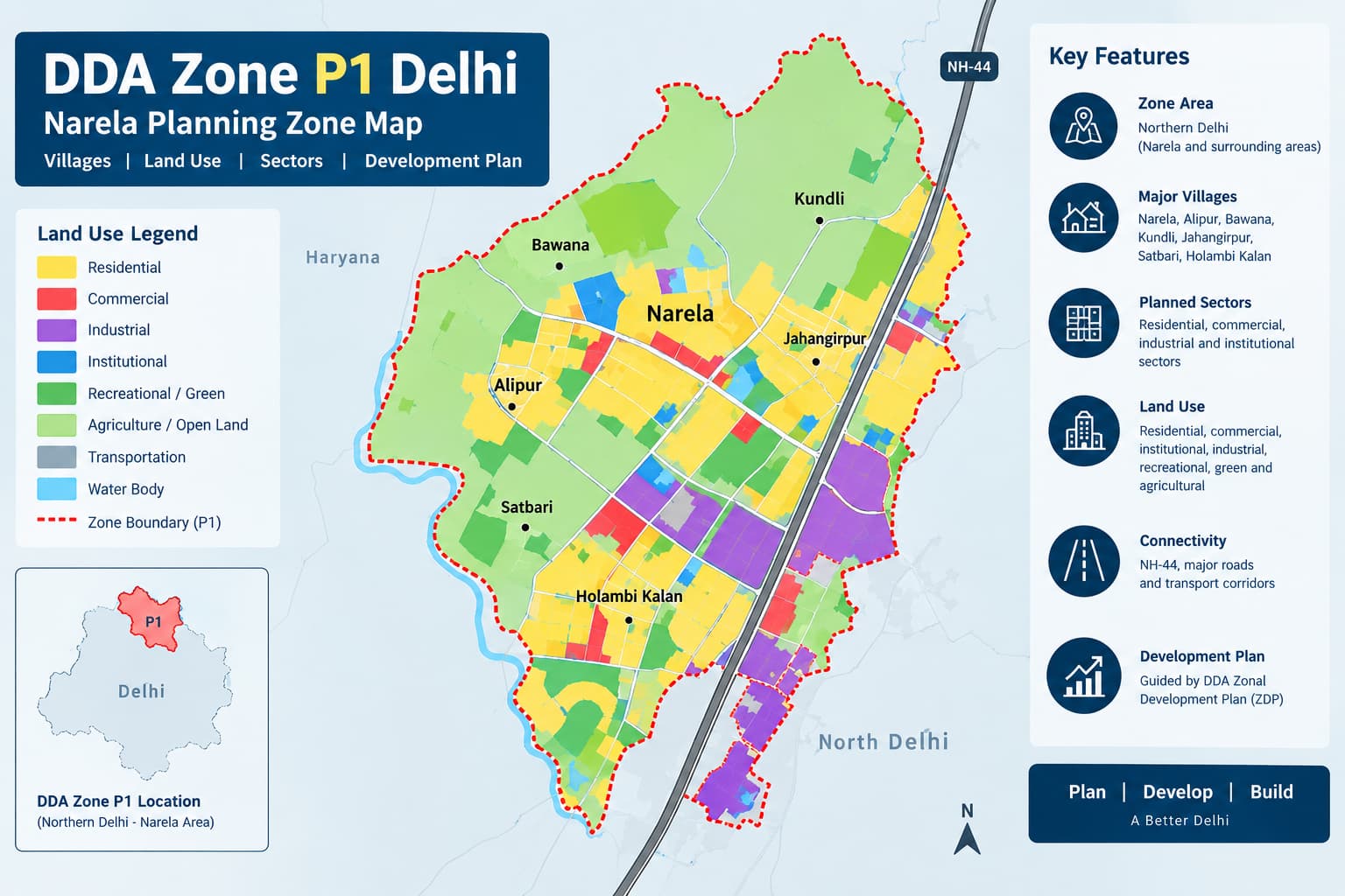
DDA Zone P 1 Narela Villages Land Plan
DDA Zone P 1 is one of the important planning zones that belong to the northern sector of Delhi and is directly related to the Narela locality. The zone covers planned development zones, villages, residential zones, commercial activities, institutional uses, transport and other land use classifications. The knowledge of the planning structure is crucial when conducting research on land or property in Narela as the name of the planning zone alone does not define the legal permission for any particular plot of land.
What Is DDA Zone P-1?
DDA Zone P-I is the planning zone utilized in the development-planning structure of Delhi. It represents a general land-use organization, infrastructure and future urban development of the zone boundaries. In the case of land research, the key distinction is that of the planning zone and particular land use classification. The inclusion in the DDA Zone P-I creates a general reference point, but the information about particular property needs to be additionally obtained.
DDA P1 Zone Map
The DDA P1 Zone Map gives the overview of the whole planning zone and may assist in the identification of the connection of villages, developed zones, roads, sectors, and different zones of land uses. It can be used as a starting point in the understanding of the position of the property in the wider context of the Delhi master planning zone. Nonetheless, the map cannot be considered as a document of the property approval. The map shows a planning designation of the area whereas the property itself may have some other conditions.
What a P-I Map Can Help You Understand
DDA Zone P1 Delhi Map and Location
The DDA Zone P1 Delhi Map would be helpful in identifying the location of P-I in relation to the city of Delhi's overall planning system. The village of Narela is significant in the context of talking about the zone, but the area for planning purposes goes beyond just one particular village. The DDA Zone P1 Map should thus be read alongside maps of villages, sectors, and land use. This is particularly relevant when a property is merely described as a “Narela plot” or “property in P-I zone.”
A useful property identification sequence is:
P-I Zone → Village/Locality → Sector → Khasra/Parcel → Land Use → Development Status
Following this sequence makes it easier to distinguish between an area's general planning characteristics and the status of a specific property.
Areas and Villages in DDA Zone
P-I has a mixture of planned zones, settlements, and villages that are part of the planning layout of the wider area in northern Delhi. Identification at the village level is crucial for any property or land-related study because the system of identification may differ between revenue and planning records. The same principle applies when reviewing areas such as Delhi L Zone and Delhi F Zone, where a broader planning-zone name does not establish the exact status or permitted use of an individual parcel. A village name cannot, by itself, be taken as proof of claims related to residential, commercial, or development use.
For land buyers, this distinction is especially relevant around areas experiencing planned or proposed urban development. A village's inclusion within a planning zone does not automatically convert every parcel into a developed residential plot.
Land Use in DDA Zone P-I
The land use planning in P-I is not limited to residential uses only. The planning structure allows for residential use, commercial use, institutional use, recreational use, transportation use, utility use, and other defined uses. The surrounding development pattern is helpful in providing context, but it cannot be considered as a final method to determine land use. Land that is surrounded by residential buildings or commercial buildings or transportation networks may have a different planning use.
This makes the DDA P1 Zone Delhi planning context important for property research, but the final determination should always move from the zone level to the individual parcel.
DDA Layout Plan
A DDA Layout Plan provides a more detailed level of planning than a broad zone map. Layout-level information can show the arrangement of plots, roads, facilities, open spaces and other planned elements within a particular development area.
Zone Map vs Layout Plan
Using the right document at the right stage helps prevent errors when researching property in P-I.
P-I Development Framework
The development structure of P-I comes through various levels of planning instead of one map. Planning at the broader level will determine the zone, but more specific documentation can cover the uses, sectors, layout, infrastructure, and development controls. When it comes to the buyer and investor, the differentiation between development and development is equally significant. A planning classification may imply the use intended or regulated without any inference of infrastructure being available on the property.
P-I and Land Pooling
Land pooling is relevant to parts of Delhi's planning framework, including specific areas where the applicable land-pooling provisions cover identified sectors and parcels. However, DDA Zone P-I should not automatically be treated as synonymous with land-pooling land.
Important Land-Pooling Checks
DDA pooling land policy — review when the property falls within an applicable land-pooling area.
Check the relevant village and sector.
Verify whether the parcel is included in the applicable pooled-land records.
Check the status of participating land and sector-level pooling.
Review infrastructure and development conditions.
Verify title and ownership separately from planning status.
Land pooling is a sector-level planning mechanism, so a general P-I location should not be treated as evidence that a particular plot has automatically become development-ready.
P-I and Property Prices
Searches for property in Narela or P-I often focus on price, but a single rate cannot represent the entire planning zone. Property values can differ according to location, road access, plot dimensions, land use, title status, development conditions and surrounding infrastructure.
Factors That Can Influence Property Value
Therefore, a quoted “P-I rate” should be treated as a market reference rather than as an official zone-wide valuation.
How to Check a Property in DDA Zone P-I
Property verification should start with the exact parcel. Obtain the complete address, village or locality name, plot details and khasra number where applicable. These details can then be matched against the relevant planning and revenue records.
Practical Verification Process
Identify the Zone
Confirm that the property falls within the P-I planning-zone boundary.
Identify the Village or Locality
Match the property with the relevant settlement or revenue village.
Check the Sector
If the property falls within a planned sector, identify the applicable sector number and planning records.
Verify the Khasra or Parcel
Match the advertised property with the actual parcel identification.
Check Land Use
Determine the applicable land-use designation rather than assuming residential use from the surrounding area.
Review Development Planning
Check relevant zonal, sector and layout-level planning information.
Check Land-Pooling Status
Where applicable, establish whether the parcel is part of the relevant land-pooling framework.
Verify Title
Planning status and ownership are separate questions, so title and transaction documents require independent verification.
DDA Zone List and P-I
The DDA Zone List provides a useful way to understand how P-I fits within Delhi's wider planning structure. Delhi is divided into multiple planning zones, and different zones have their own geographic characteristics, development patterns and planning documents.
Common Mistakes About DDA Zone P-I
Assuming P-I means residential
P-I contains different land-use categories. The planning zone itself does not establish that a property is residential.
Treating Narela as one uniform property market
Narela and surrounding areas contain different types of properties and development conditions. Exact location and documentation matter.
Assuming a DDA map proves ownership
Planning maps provide planning information. Ownership must be established through appropriate legal and revenue documentation.
Assuming every P-I parcel is part of land pooling
Land pooling applies only where the relevant provisions and records cover the property. The zone name alone is not sufficient.
Confusing a layout plan with a title document
A layout plan explains planned physical development. It does not replace ownership or title records.
Relying only on advertised property descriptions
Terms such as “DDA plot,” “P-I approved plot” or “Narela land” should be verified against the underlying planning and property records.
Related DDA Planning Topics
FAQs
What is DDA Zone P-I?
DDA Zone P-I is a designated planning zone in northern Delhi associated closely with the Narela area. It contains different settlements, land uses and planned development areas.
Is DDA Zone P-I the same as Narela?
Narela is an important reference point for P-I, but the planning zone should not be treated as identical to one locality. The exact property location needs to be checked against the applicable planning boundary.
Where can I find the DDA P1 Zone Map?
The DDA P1 Zone Map can be used as a broad planning reference to understand the zone boundary, areas, sectors and other planning features. Individual properties require more detailed verification.
Does a P-I map prove that a plot is approved?
No. A planning map identifies the broader planning framework but does not by itself establish ownership, title, permitted construction or development eligibility.
Is land pooling applicable in P-I?
Land pooling can apply to specifically identified areas and sectors. A particular P-I property needs to be checked against the applicable land-pooling records rather than being assumed to qualify because of its zone.
What is the importance of a DDA Layout Plan?
A layout plan provides detailed information about the planned arrangement of plots, roads, facilities and open spaces within a particular development area. It does not replace title or ownership documentation.
How should I verify a P-I property?
Start with the planning zone, then identify the village or locality, sector, khasra or parcel, applicable land use, development status and, where relevant, land-pooling status. Ownership and title should be verified separately.
Conclusion
Planning using DDA Zone P-I is useful for studying the developmental pattern of the north Delhi region and the Narela region. All the aspects like villages, sectors, land use zones, infrastructure plan and development zones must be taken together into consideration rather than looking at just the zone name. The best way of doing property research would be by going from the general DDA P1 Zone Map to specific villages, sectors and parcel details followed by determining the land use zone, development zones, land pooling scheme and titles.