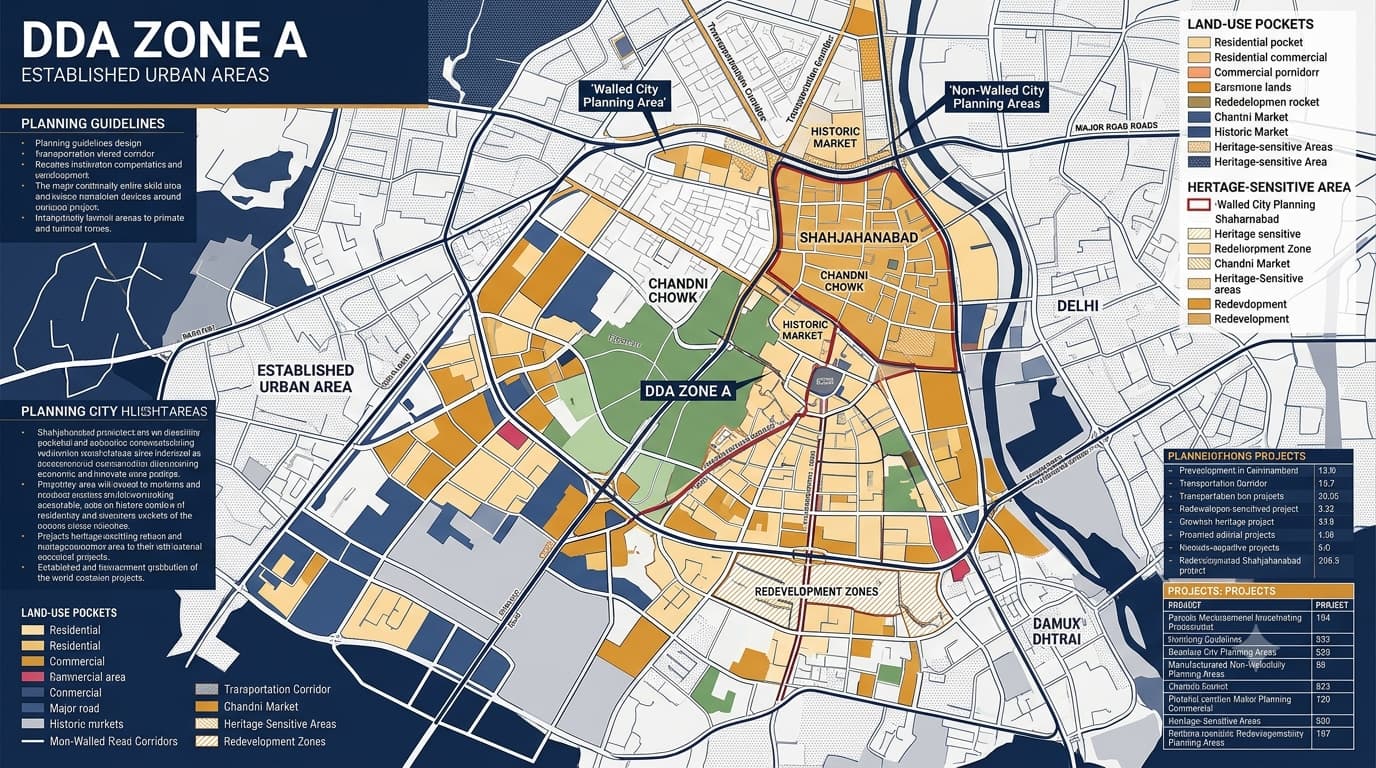
DDA A Zone Delhi Areas, & Localities Map
The DDA A Zone forms the Old City zoning in Delhi which includes the historic walled city and other urbanized zones. It is spread over an area of about 1,159 hectares and has an urban character formed through historic settlements, market places, residential zones, commercial uses, transport infrastructure and civic amenities. Any research related to land use or development planning in such a zone will require knowledge of its planning framework.
DDA Zone A at a Glance
Zone A is not a development area that is homogenous. The nature of its planning varies from the Walled City, the market, the settled residential areas, to the commercial zones. Hence, research for property should not end at the zone boundary, but should go further to analyze the specific locality and planning.
Areas and Localities in DDA A Zone
Several historic and established areas are associated with this planning zone. Their land-use patterns and development conditions can vary.
The locality name alone should not be considered proof of permitted land use. The exact property needs to be assessed against the applicable planning and property records.
Walled City and Areas Outside the Walled City
There exists a major difference in terms of planning within A Zone Delhi with respect to the Walled City and those areas that lie outside of it. The Walled City has a historic layout with narrow streets, traditional bazaars and old buildings/heritage places. Those areas that lie outside the Walled City include Paharganj, Jhandewalan, Sadar Bazar, and Qadam Sharif.
Key Planning Characteristics
Historic and established urban fabric
High-density built-up areas
Traditional residential settlements
Major commercial and wholesale markets
Mixed-use development
Heritage structures and historic precincts
Major roads and transportation corridors
Public and institutional facilities
Redevelopment and urban renewal requirements
Localised planning and layout considerations
For comparison, DDA Zone F has a different planning character associated with established South Delhi residential, institutional and commercial areas. The planning context of DDA K1 Zone and DDA K2 Zone is also different from the historic urban structure of Zone A.
Land Use in DDA Zone A
Land use is one of the most important factors when evaluating a property. Residential, commercial, mixed-use, public and semi-public, transportation, recreational and utility-related uses occur across different parts of the planning area.
For a broader understanding of Delhi's land-use structure, DDA Land Use in Delhi can be used alongside the zone-level planning information. Existing activity around a property should not automatically be treated as proof of its permitted use. The applicable land-use designation and planning documents should be checked separately.
DDA Zone A and Zonal Development Plan
The DDA Zonal Development Plan becomes an important tool in planning between the Master Plan and layout planning. As for an already existing area such as Zone A, it can help us understand the connection between land uses, circulation, open spaces, and development.
Important planning elements include:
Existing and proposed land uses
Major circulation routes
Public and semi-public facilities
Parks and open spaces
Planning sub-zones
Urban renewal and redevelopment considerations
Historic and heritage-sensitive areas
Relationship between zonal and detailed layout planning
The wider planning framework can also be understood through Delhi Master Plan 2047, while property-level research still requires examination of the applicable locality, layout and property records.
Zone A Layout and Sub-Zone Planning
The broad zone boundary is only the first step. Identifying the applicable sub-zone or planning area can provide more specific information.
DDA Zone A Property Verification
Property research should not stop after confirming that an address falls within Zone A. DDA Property Verification should consider the exact property, its land use, applicable layout and relevant property records.
Practical Property Research Sequence
Identify the exact property address and locality.
Confirm the applicable planning zone and sub-zone.
Check the land-use designation.
Review the relevant layout or development plan.
Examine property and plot records.
Verify ownership and title separately.
Compare existing use with the planning framework.
Review applicable development controls.
Check road access and infrastructure.
Identify any heritage, conservation or redevelopment considerations.
Redevelopment Considerations
Zone A includes older parts of Delhi, and redevelopment in such zones will be complicated compared to new planned zones. Such old buildings, roads, markets, infrastructure capacity, and conservation will affect development requirements.
Such important aspects include:
Existing building
Existing land use
Layout requirements
Redevelopment requirements
Conservation requirements
Development control and building control
Road width and access
Parking and circulation
Infrastructure capacity
Approvals required
The redevelopment possibility must be considered using the planning requirement rather than considering the commercial activities in the area.
DDA Zone A in the Wider Zone Planning Structure
Delhi's planning zones have different development histories and planning characteristics.
This comparison shows why the research approach for a historic central zone should not automatically be applied to peripheral development areas.
DDA Zone A and Land Pooling
Land pooling is more relevant to certain peripheral and urbanisable planning areas than to the established historic fabric of Zone A. Readers researching areas where land pooling is important can refer to the DDA Land Pooling Policy for the broader planning context. Being located within a DDA planning zone does not automatically mean that a property is part of a land-pooling scheme or eligible for the same development mechanism.
Different Property Situations in Zone A
Common Mistakes While Researching DDA Zone A Property
Taking for granted that all the properties have similar zoning.
Considering the local name to be a sufficient indicator of permissible use.
Not recognizing the distinction between Walled City and others.
Considering past commercial activities to imply commercial permission.
Disregarding the relevant plan.
Assuming re-development is certain.
Not taking into account issues of heritage or conservation.
Just checking the website listing of the property.
Relying on an old planning map.
Confusing zonal planning with development permission for the property.
Taking for granted that land pooling is possible in all DDA planning zones.
FAQs
What is DDA Zone A?
DDA Zone A is the Old City planning zone of Delhi. It includes the historic Walled City and other established urban areas with residential, commercial, mixed-use, institutional and heritage-related development.
What is the approximate area of DDA Zone A?
The planning area is approximately 1,159 hectares and includes both the Walled City and areas outside it.
Which areas are associated with DDA Zone A?
Important areas include Chandni Chowk, Kashmere Gate, Daryaganj, Matia Mahal, Balli Maran, Paharganj, Sadar Bazar, Jhandewalan, Qadam Sharif, Bara Hindu Rao, Pahari Dhiraj and Azad Market.
Does being in DDA Zone A automatically allow residential or commercial development?
No. The zone designation alone does not determine the permitted use of an individual property. Land use, layout, development controls and property records must be checked.
Why is the DDA Zonal Development Plan important?
It provides a detailed planning layer between the broader Master Plan and detailed layout planning, helping explain land use, circulation, facilities, open spaces and development structure.