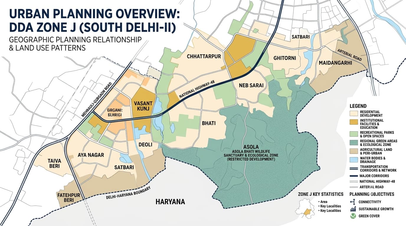
DDA Zone J, which is referred to as South Delhi-II, is one of the largest urban planning zones covering parts of Southern Delhi. It contains various areas such as Vasant Kunj, Chhattarpur, Ghitorni, Neb Sarai, Asola, Bhati, Deoli, Aya Nagar, Fatehpur Beri, and Satbari. Contrary to the urban planning zones, That is characterized by varied land usage that includes urban residential areas, urban villages, institutional sites, transport corridors, green spaces, Asola Wildlife Sanctuary/Ridge Landscape, agricultural land and other land usages. The current planning map from DDA shows the zone as an area of 22,979 hectares. In comparison, the MPD-2021 zone table shows South Delhi-II as an area of 15,178 hectares. These two data sources cannot be added up since each is based on different planning datasets. More importantly, the zone area data is secondary to property-specific land-use plans. Zone J comprises a substantial portion of southern Delhi and stretches into areas near the Delhi-Haryana border along with several significant southern settlements both rural and urban. The designated Zonal Development Plan map marks significant planning zones around it, as well as links to Zone F, Zone G, and Haryana/Faridabad. For understanding the map, the important areas include: Vasant Kunj Chhattarpur Ghitorni Neb Sarai Asola Bhati Deoli Aya Nagar Fatehpur Beri Gadaipur Chandan Hula Satbari Rajpur Khurd Maidangarhi The Zone J map should therefore be read as a large planning area with different land-use environments, rather than as a single continuous residential district. The DDA's Zone records identify numerous villages and settlements. The notified planning material includes Aya Nagar, Asola, Bhati, Chandan Hula, Chhattarpur, Deoli, Fatehpur Beri, Gadaipur and Ghitorni, among other areas. The exact planning status of an individual property should always be checked separately because a locality can contain multiple land-use categories. The land use pattern for Zone is more diverse compared to other developed zones in central Delhi. The Zonal Development Plan provides various classifications like residential, recreational, public and semi-public institutions, transport, utility, governmental institutions, agricultural zones and water bodies. This diversity is important when reading a DDA Zone J Land Use Map. A property within the same broad locality can be subject to very different planning controls depending on its exact plot and designated use. The residential zones are developed in planned zones as well as existing colonies. One of the main planned residential zones of Zone J is Vasant Kunj. The DDA layout plan files have various plans relating to Vasant Kunj residential sectors and institutional zones. For property research, check: Exact plot location Land-use designation Revenue village Layout plan Ownership documents Road/access conditions Applicable development controls Existing approvals and permissions Several institutional and commercial planning elements have been incorporated in Zone J, especially in terms of the existing development in southern Delhi. The Zonal Development Plan includes hospitals, education/research institutes, religious, and sports facilities in both public and semi-public planning. The official Zone J map identifies: Regional Park District Park City Park Historical monuments Asola Wildlife Sanctuary Green Belt Agricultural areas Water bodies This also means that land availability in Zone J should not be judged simply by looking at vacant parcels on a general map. Some apparently open areas can have specific recreational, ecological, agricultural or other designated planning purposes. Zonal Development Plan of DDA is the Planning Framework for South Delhi-II. This planning framework was drafted under the guidelines of MPD-2021. The notification for this was put up in March 2008. This Planning Framework was finalized thereafter after the appropriate process of the relevant Delhi Development Act. The Zonal Development Plan is a linkage between the Delhi Master Plan and the layout planning. It covers subjects such as: Land-use distribution Residential development Recreational areas Public and semi-public facilities Transportation Utilities Government land Agricultural areas Water bodies Green areas MRTS/LRT corridors Major road networks The map itself also carries an important planning limitation: the ZDP does not establish property ownership. DDA Zone J Layout Plans Detailed layout plans are particularly important in Zone J because the zone contains many different types of development. Current DDA records include layouts and utilisation plans for areas such as: Neb Sarai Ghitorni Aya Nagar Satbari Rajpur Khurd Maidangarhi Mahipalpur Tughlakabad Rangpuri Facility Corridor along NH-8 For this reason, a DDA Zone J Map is useful for understanding the overall planning structure, but an individual property should be checked against the relevant detailed layout and land-use record. A property being located within Zone J does not by itself establish its permitted use or development potential. Before purchasing, developing or investing in a property, verify: Exact plot and property location Revenue village and khasra details Ownership and title documents DDA land-use designation Applicable layout plan Road access and right of way Development controls Building permissions Whether the proposed use is permitted Any applicable environmental, green-area or other planning restrictions It is particularly significant in Zone J, wherein there could be residential areas, urban villages, institutional land use, agricultural land use, and environmentally fragile areas that all fall under one single zoning area for planning. DDA Land Use in Delhi and DDA Property Verification may be considered for in-depth research along with the zoning information. Zone J does not exist in isolation. Its planning geography connects with other southern and western planning areas. The exact boundary should always be taken from the relevant DDA zonal map rather than inferred from locality names. DDA Zone J is officially known as South Delhi-II. It covers a large southern Delhi planning area containing Vasant Kunj, Chhattarpur, Ghitorni, Neb Sarai, Asola, Bhati, Deoli and several other settlements. Major areas include Vasant Kunj, Chhattarpur, Ghitorni, Neb Sarai, Asola, Bhati, Deoli, Aya Nagar, Fatehpur Beri, Satbari, Rajpur Khurd and Maidangarhi. The planning area contains residential, recreational, public and semi-public, transportation, utility, government, agricultural and water-body related land uses. Yes. DDA's planning and layout records include Vasant Kunj and multiple residential, institutional and facility-related layouts in the area. Yes. Asola is identified among the areas associated with the planning zone and is also important because of the wider green and wildlife-related planning context. DDA's current planning page lists 22,979 hectares, while the MPD-2021 zone table lists 15,178 hectares for South Delhi-II. These figures come from different official planning records and should not be treated as a single current figure. No. The zone map provides planning information, but property development depends on the applicable land use, detailed layout, development controls, ownership documents and required permissions.DDA Zone J Location Map Plan
DDA Zone J at a Glance
DDA Zone J Map: Where Is It Located?
DDA J Zone Areas and Localities
DDA J Zone Land Use
Residential Development
Commercial and Institutional Development
Green Areas, Regional Parks and Asola Landscape
DDA Zone J Zonal Development Plan
What to Check Before Buying Property in Zone J
Zone and Its Adjoining Planning Areas
FAQs
What is DDA Zone J?
Which areas come under this planning area?
What is the land use of this area?
Is Vasant Kunj part of this planning area?
Is Asola included in this planning area?
What is the area of DDA Zone J?
Can the DDA Zone J map confirm whether a property can be developed?