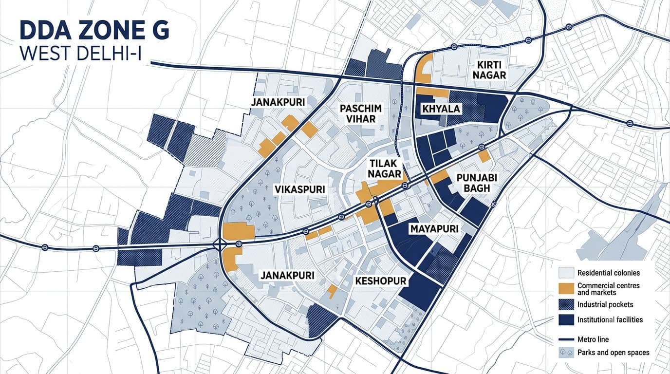
DDA Zone G, whose official designation is West Delhi-I, is a planning zone that encompasses already existing zones in West Delhi. According to the current listing of the DDA Zonal Plans, the zone covers an area of 5,677 hectares. The zones consist of residential colonies, commercial zones, industrial zones, institutional zones, parks, facility zones and old zones. Some of the notable zones include Janakpuri, Paschim Vihar, Vikaspuri, Tilak Nagar, Punjabi Bagh, Mayapuri, Kirti Nagar, Tagore Garden, Subhash Nagar, and Karampura among others. DDA planning and zoning records have also identified Khyala, Keshopur, Kapashera and Bijwasan in planning documents. When looking for a map for DDA G Zone, you should not just rely on the boundaries of the zone. There is other information about the zones that will be important for you including the localities in the planning zones, land use classification, the location of the residential and industrial pockets and the applicable layout of the area. Important area note: older DDA documents have used a larger figure of 11,865 hectares for Zone G. The current DDA Zonal Plans page lists 5,677 hectares, so the current official figure should be preferred when presenting the present-day zone overview. DDA G Zone Map: Location and Areas Covered The DDA Zone G Map needs to be considered as a planning map and not just a locality map. The map locates West Delhi-I as part of the planning scheme of Delhi and indicates the location of different uses such as residential, commercial, industrial, institutional, recreational and transportation uses. There are various localities that belong to Zone of West Delhi as per the planning documentation of DDA. This zone has been further divided by the DDA into smaller planning zones such as G-10, G-13 and G-17. The following areas are useful starting points when researching DDA Zone Areas and DDA Zone Localities. DDA records specifically identify several of these locations in Zone planning or layout material. The DDA Zone Land Use Pattern illustrates the diversified nature of the development of West Delhi-I. There is dominance of residential land use pattern but there are commercial centers, industries, institutions, recreations and transportations within this zone. According to DDA, “Zonal Development Plan indicates the existing and proposed use zones and serves as the link between the Master Plan and Layout Plans.” However, it should be noted that the land-use classification within the Zonal Development Plan does not confer any automatic right on the owner to use land for such purpose. This is why DDA Zone G Land Use should always be checked at the appropriate planning and property level rather than inferred from the surrounding development. The DDA Zone G Zonal Development Plan provides the planning framework for West Delhi-I and connects the broader Master Plan with more detailed layout planning. DDA currently provides a Zone G report, map and Gazette notification under its MPD-2021 Zonal Development Plan section. The Zonal Development Plan is useful for understanding: Existing and proposed land-use areas Residential development Commercial centres Industrial areas Public and semi-public facilities Parks and open spaces Transportation and circulation Community facilities Planning and development requirements For readers researching the broader DDA system, DDA Zonal Development Plan information can be compared with DDA Zone F, DDA Zone H and other zone-specific planning pages. Zone level plans do not have all the information required for each individual property. This is where layout plans become relevant. Layout plans currently available with DDA include various Zone G layout plans such as Janakpuri residential and institutional layouts, layouts of Paschim Vihar, layouts of Paschim Puri, group housing layouts and modification of facility centre layouts. The existence of a DDA layout does not by itself establish ownership or development rights. The exact property must still be matched with the relevant plan and legal documents. If you are evaluating a property in DDA Zone, the most important next step after identifying the locality is DDA Property Verification. Identify the exact property, plot, block or pocket. Locate the applicable DDA Zone G Map and detailed layout. Check the property's designated land use. Verify ownership and title documents. Check building and development approvals. Review road access and any relevant layout modification. Check whether the site is affected by facility, park or other reservations. Obtain professional legal advice before completing a transaction. Another crucial component of Zone is open space planning. There is one community park on the Outer Ring Road within Paschim Vihar. DDA estimates that the park occupies about 47.09 acres (19.06 hectares) and serves such functions as recreation, rainwater recharge and urban ecology. The importance of this fact lies in interpretation of the DDA Zone Map: open and recreational lands on a planning map should not be considered as usual developable lands. It would be wrong to automatically assume that DDA Land Pooling Policy can be applied to all properties within Zone G. A great deal of West Delhi-I area is represented by already developed urban area, planned colonies, industrial zones, commercial districts and settlements. If one is interested only in evaluating the possibility of land pooling on a particular property, the particular parcel and the planning status of this parcel should be defined first. The same thing concerns the Delhi Master Plan 2047: it gives the perspective on future planning, but not the development permission. This comparison places DDA Zone G within the wider Delhi planning structure without treating all zones as having the same development pattern. DDA Zone G is West Delhi-I, a planning zone containing established residential, commercial, industrial, institutional and mixed urban development. The current DDA Zonal Plans page lists 5,677 hectares for Zone G. Older DDA documents have cited a larger 11,865-hectare figure, so the date and planning document should always be checked when comparing area figures. Important areas include Janakpuri, Paschim Vihar, Vikaspuri, Tilak Nagar, Punjabi Bagh, Mayapuri, Kirti Nagar, Tagore Garden, Subhash Nagar and Karampura. DDA planning records also reference Khyala, Keshopur, Kapashera and Bijwasan. Zone G has a mixed land-use structure. Residential development is prominent, but commercial, industrial, institutional, recreational and transportation uses are also present. First identify the exact property or plot and match it with the relevant DDA layout and land-use record. The broad zone designation alone is not sufficient to establish the permitted use of an individual property. Yes. DDA planning and layout records identify Kirti Nagar within Zone G, including industrial and warehouse-related layouts. No. A property's location within a planning zone does not by itself establish development rights. The applicable land use, layout, ownership documents, permissions and development controls must be checked.DDA Zone G Areas Map Plan
DDA Zone G at a Glance
DDA Zone G Areas and Localities
DDA Zone G Land Use
DDA Zonal Development Plan
DDA Layout Plans
Property Verification in Zone G
A practical verification sequence
Parks and Open Spaces
Zone G and Land Pooling
DDA Zone G Compared With Other Zones
FAQs
What is DDA Zone G?
What is the area of DDA Zone G?
Which areas come under DDA Zone G?
What is the main land use in DDA Zone G?
How can I check the land use of a property in Zone G?
Is Kirti Nagar part of DDA Zone G?
Does being in DDA Zone G automatically give development rights?